 Filter: Categories of Wisconsin Historical Images
Filter: Community of Portage
Filter: Creator Name of Unknown
Filter: Categories of Wisconsin Historical Images
Filter: Community of Portage
Filter: Creator Name of Unknown
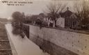
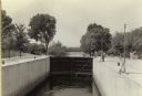
| Date: | 1910 |
|---|---|
| Description: | The Portage Canal at the Wisconsin River, showing the upper lock. Caption reads: "Upper Lock and Wisconsin River Portage Wis. No. 10". A group of people ar... |

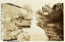
| Date: | 1915 |
|---|---|
| Description: | The Portage canal looking east from the Canal Bridge. Boats are lines up along the shoreline on the left near a long building. |
| Date: | 02 05 1928 |
|---|---|
| Description: | Slightly elevated view of the Portage Canal, looking east from the canal bridge. A man is standing on a large platform on the left side of the canal near a... |
| Date: | 1935 |
|---|---|
| Description: | A view of the Portage Canal. In the immediate foreground is the Fox River, then the lower locks and the canal itself. The Indian Agency House may be seen t... |

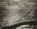
| Date: | 1945 |
|---|---|
| Description: | An aerial view of the Portage Canal, Fox and Wisconsin Rivers. |
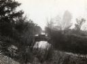
| Date: | 1929 |
|---|---|
| Description: | A view of the canal locks on the Fox River. The Indian Agency House is in the background on a hill. |
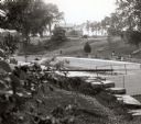
| Date: | 1935 |
|---|---|
| Description: | A view of the canal locks of the Portage Canal. Men are standing at the edge of the locks on the right. |
| Date: | 1945 |
|---|---|
| Description: | An elevated view of Portage and it's vicinity. |
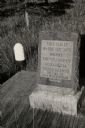
| Date: | 1940 |
|---|---|
| Description: | A marker at the site of the former village of Oshaukuta on Highway 51, north of Portage. The marker states: "This tablet marks the site where the village o... |
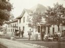
| Date: | 1900 |
|---|---|
| Description: | Group posing on lawn outside of the large brick building with a steep hip roof. Four men are identified (from left to right) as the turnkey, William MacKen... |

| Date: | 1800 |
|---|---|
| Description: | This map shows the land claim owned by the Portage Canal Company and includes an index of landownership and landmarks. The Wisconsin and Portage River, the... |

| Date: | 1800 |
|---|---|
| Description: | This map is pencil on tracing paper and shows marshes, the Wisconsin River, Indian trails, and Indian boundary line. The upper left corner reads: "Let sect... |
| Date: | 1950 |
|---|---|
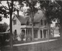
| Description: | Residence in Portage that was the birthplace of Frederick Jackson Turner. |
| Date: | 09 27 1908 |
|---|---|
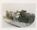
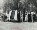
| Description: | Three-quarter view from front right of the badly damaged Engine No. 423 of the Chicago, Milwaukee and St. Paul Railway. The boiler remains on the railroad ... |
| Date: | 06 30 1957 |
|---|---|
| Description: | View across lawn towards a crowd, with costumed participants dressed as Native Americans, fur traders, and Jacques Marquette, at the dedication of the Marq... |
| Date: | 07 1966 |
|---|---|
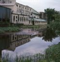
| Description: | View across canal towards the back of the Portage Hosiery. Reeds and trees are along the edge of the canal. Red and pink colored liquid is floating on the ... |
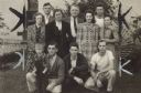
| Date: | |
|---|---|
| Description: | Four women, six men, and one boy pose together. Caption reads: "OFFICIALS AND NEGOTIATING COMMITTEE of Hosiery Branch 169 were instrumental in winning the ... |
If you didn't find the material you searched for, our Library Reference Staff can help.
Call our reference desk at 608-264-6535 or email us at: