 Filter: Categories of Wisconsin Historical Images
Filter: Community of Plymouth
Filter: Subject of rivers
Filter: Categories of Wisconsin Historical Images
Filter: Community of Plymouth
Filter: Subject of rivers
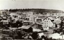
| Date: | 1868 |
|---|---|
| Description: | A view taken from the elevation on the south side of the Mullet River. |
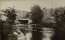
| Date: | 1910 |
|---|---|
| Description: | View of the Mullet River, with an bridge and an industrial building in the background. A sign reads, in part: "MFG. CO." |

| Date: | |
|---|---|
| Description: | Elevated view of a village located at the junction of Beebe River and Pemigewasset River. |

| Date: | 1959 |
|---|---|
| Description: | This map shows some land ownership, lot and block numbers, additions, fair grounds, streets, and railroads and is indexed. Mullet River and Mill Pond are l... |

| Date: | 1940 |
|---|---|
| Description: | A young boy wearing knickers, high stockings and a jacket is watching two swans on the Mullet River. A bridge and the rear of commercial buildings are in t... |
If you didn't find the material you searched for, our Library Reference Staff can help.
Call our reference desk at 608-264-6535 or email us at:
