Filter: Categories of Wisconsin Historical Images
Filter: Community of Oshkosh
Filter: Year of 1900-1999
Filter: Categories of Wisconsin Historical Images
Filter: Community of Oshkosh
Filter: Year of 1900-1999

| Date: | 1950 |
|---|---|
| Description: | This map of the business section of Oshkosh shows businesses and lot owners. The map is oriented with north to the left and includes 2 "continued inset" ma... |
| Date: | 1962 |
|---|---|
| Description: | Factories on Custer Avenue. On the left is the Waite Carpet Co., and in the background is the CKL Machinery Co. |
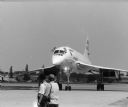
| Date: | 08 1998 |
|---|---|
| Description: | The British Concord makes an appearance at the EAA in Oshkosh. |
| Date: | 08 1998 |
|---|---|
| Description: | The British Concord lands at the EAA Airshow in Oshkosh. |

| Date: | 08 1998 |
|---|---|
| Description: | The pilot of the British Concord at the Experimental Aircraft Association's (EAA) Air Show waves to the crowd. |

| Date: | 1902 |
|---|---|
| Description: | Hand-colored view of a horse and carriage decorated for a parade. Jessie Jack Hooper, wearing a floral hat, holds a decorated parasol in the front seat. A ... |

| Date: | 09 1950 |
|---|---|
| Description: | This map show streets, points of interest, Lake Winnebago and bays, Lake Butte Des Morts, and the Fox River. The back of the map includes a directory of t... |

| Date: | 1962 |
|---|---|
| Description: | This map shows streets, points of interest, Lake Winnebago, Millers Bay, South Asylum Bay, Lake Butte des Morts, and the Fox River. The map also includes a... |

| Date: | 1962 |
|---|---|
| Description: | This map shows streets, points of interest, Lake Winnebago, Millers Bay, South Asylum Bay, Lake Butte des Morts, and the Fox River. The map also includes a... |

| Date: | 1925 |
|---|---|
| Description: | View from bridge or boat railing of piles of lumber in the Paine Lumber Company yards on the banks of the Fox River. There is a boat house on the left shor... |

| Date: | 1930 |
|---|---|
| Description: | This map shows city wards, streets, railroads, parks, Lake Butte Des Morts, Lake Winnebago, advertisements for Dixie Oils Gasoline, a list of Cook & Brown ... |
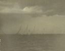
| Date: | 08 1916 |
|---|---|
| Description: | Class A sailboats race in the Inland Lake Yachting Association Regatta on Lake Winnebago just before a storm breaks. There are threatening clouds overhead. |
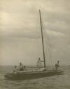
| Date: | 08 1916 |
|---|---|
| Description: | A description of this photograph written by Ernst Schmidt reads: "The 'Senta' with the anchor out shortly after the storm had hit. I am on the after deck —... |
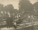
| Date: | 08 1916 |
|---|---|
| Description: | Bystanders watch as men bail out a sailboat and others assess the damage to their craft after a storm hit during the Inland Lake Yachting Association Regat... |

| Date: | 08 18 1931 |
|---|---|
| Description: | View across water towards sailboats with their crews reflected in the still waters of Lake Winnebago, before the start of a race at the Inland Lake Yachtin... |

| Date: | 1908 |
|---|---|
| Description: | This blueprint map is showing subdivisions and additions. Streets, rivers, and land plots are labeled. |

| Date: | 1900 |
|---|---|
| Description: | Map showing a paper city located on the shore of Green Bay and south shore of the Fox River. The site is now part of Oshkosh. |

| Date: | 1900 |
|---|---|
| Description: | Map showing city wards, streets, block and lot numbers, additions, selected buildings, Lake Winnebago, the Fox River, and railroads as of 1895. The lower m... |

| Date: | 1926 |
|---|---|
| Description: | This blueprint map is oriented with north to the upper left. The map shows buildings with note of those "to be torn down," sidewalks, proposed power plant,... |
If you didn't find the material you searched for, our Library Reference Staff can help.
Call our reference desk at 608-264-6535 or email us at: