 Filter: Categories of Wisconsin Historical Images
Filter: Community of Oshkosh
Filter: Subject of cities and towns
Filter: Categories of Wisconsin Historical Images
Filter: Community of Oshkosh
Filter: Subject of cities and towns
| Date: | |
|---|---|
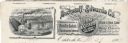
| Description: | Memohead of the Buckstaff-Edwards Company of Oshkosh, Wisconsin, manufacturers of coffins and caskets and wholesale dealers in caskets and undertaking supp... |
| Date: | |
|---|---|
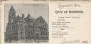
| Description: | Letterhead of the City of Oshkosh, Comptroller's Office, with a three-quarter view of the city hall, people standing or walking by the building, and a hors... |

| Date: | 1969 |
|---|---|
| Description: | A woman wearing a paisley dress is carrying a United Farmworkers (UFW)/AFL-CIO sign in front of a Kroger store that reads, "Honor Picket Line/ National Cou... |

| Date: | 1969 |
|---|---|
| Description: | Four frames from a contact sheet containing images of grape boycott picketers. The picketers are in front of a Krogers grocery store. In frame 34, Sandi Ut... |

| Date: | 1950 |
|---|---|
| Description: | This map of the business section of Oshkosh shows businesses and lot owners. The map is oriented with north to the left and includes 2 "continued inset" ma... |

| Date: | 1962 |
|---|---|
| Description: | Factories on Custer Avenue. On the left is the Waite Carpet Co., and in the background is the CKL Machinery Co. |

| Date: | 1902 |
|---|---|
| Description: | Hand-colored view of a horse and carriage decorated for a parade. Jessie Jack Hooper, wearing a floral hat, holds a decorated parasol in the front seat. A ... |

| Date: | 09 1950 |
|---|---|
| Description: | This map show streets, points of interest, Lake Winnebago and bays, Lake Butte Des Morts, and the Fox River. The back of the map includes a directory of t... |

| Date: | 1962 |
|---|---|
| Description: | This map shows streets, points of interest, Lake Winnebago, Millers Bay, South Asylum Bay, Lake Butte des Morts, and the Fox River. The map also includes a... |

| Date: | 1962 |
|---|---|
| Description: | This map shows streets, points of interest, Lake Winnebago, Millers Bay, South Asylum Bay, Lake Butte des Morts, and the Fox River. The map also includes a... |

| Date: | 1930 |
|---|---|
| Description: | This map shows city wards, streets, railroads, parks, Lake Butte Des Morts, Lake Winnebago, advertisements for Dixie Oils Gasoline, a list of Cook & Brown ... |

| Date: | 1858 |
|---|---|
| Description: | This map shows city wards, streets, block and lot numbers, cemeteries, buildings, landownership, forests, railroads, a race course, quarries, and orchards.... |

| Date: | 1877 |
|---|---|
| Description: | This map shows the Fox River, Lake Winnebago, city wards, lot and block numbers, landownership, selected buildings, railroads, and roads. There are three i... |

| Date: | 1908 |
|---|---|
| Description: | This blueprint map is showing subdivisions and additions. Streets, rivers, and land plots are labeled. |

| Date: | 1855 |
|---|---|
| Description: | This map shows the Fox River, Lake Winnebago, streets, and plats. Below the title reads: "N. F.&Co. will make surveys of lands and plat the same in the bes... |

| Date: | 1900 |
|---|---|
| Description: | Map showing a paper city located on the shore of Green Bay and south shore of the Fox River. The site is now part of Oshkosh. |

| Date: | 1900 |
|---|---|
| Description: | Map showing city wards, streets, block and lot numbers, additions, selected buildings, Lake Winnebago, the Fox River, and railroads as of 1895. The lower m... |

| Date: | 1926 |
|---|---|
| Description: | This blueprint map is oriented with north to the upper left. The map shows buildings with note of those "to be torn down," sidewalks, proposed power plant,... |
| Date: | 1908 |
|---|---|
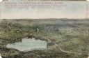
| Description: | Illustrated postcard of Lake Winnebago and the surrounding communities. Text on front reads: "Looking northwest from the east shore of Lake Winnebago showi... |
If you didn't find the material you searched for, our Library Reference Staff can help.
Call our reference desk at 608-264-6535 or email us at:
