 Filter: Categories of Wisconsin Historical Images
Filter: Community of New Orleans
Filter: Subject of water
Filter: Categories of Wisconsin Historical Images
Filter: Community of New Orleans
Filter: Subject of water
| Date: | |
|---|---|
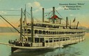
| Description: | The sternwheel excursion, Sidney, on the Mississippi River at New Orleans. All three decks are full of passengers. Later named "Washington." |

| Date: | 1859 |
|---|---|
| Description: | On an excursion to the South in November 1859, Hölzlhuber made the three-day trip on the steamboat Planet from St. Louis to New Orleans. In the harb... |
| Date: | |
|---|---|
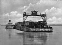
| Description: | View of Southern Pacific Railroad cars being transferred across the Mississippi River with a barge near New Orleans. |
| Date: | |
|---|---|
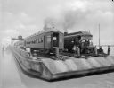
| Description: | View across water toward a railroad train and locomotive on a ferry going across the Mississippi River near New Orleans. |
| Date: | 1901 |
|---|---|
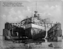
| Description: | The USS Illinois in the largest floating dry dock in the world at the time, surrounded by rowboats in the foreground. The battleship was built at Ne... |
| Date: | |
|---|---|
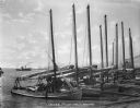
| Description: | Lugger (Picayune) Landing with sailboats and fishing boats. Boats and ships are in the background. Caption reads: "Lugger [Picayue] Landing." |

| Date: | 01 10 1942 |
|---|---|
| Description: | S.S. Robert M. La Follette splashing into the Industrial Canal at its launch. |

| Date: | |
|---|---|
| Description: | Harold Gauer and Robert Bloch on the deck of a boat near the railing acting as if they were seasick. In the background is another ship tied up at a dock, a... |
| Date: | |
|---|---|
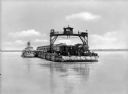
| Description: | View of a barge transporting railroad cars and an engine across a river. Several men are on the barge, including one on an overhead structure. Text on phot... |
| Date: | |
|---|---|
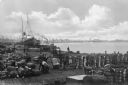
| Description: | Elevated view of a dock scene, where workers are preparing bales of cotton for loading. A steamship and a tugboat are nearby. More ships and the shoreline ... |

| Date: | |
|---|---|
| Description: | A group of men wearing hats gathered around a water pump. Scaffolding surrounds the operation and a large pulley is visible. Text on image reads "Largest f... |

| Date: | |
|---|---|
| Description: | View of railroad cars being ferried across the river. |

| Date: | 1759 |
|---|---|
| Description: | Map of New Orleans at the start of the French & Indian War, including two inset maps entitled "The Course of the Mississipi River from Bayagoulas to the Se... |

| Date: | 1769 |
|---|---|
| Description: | Map of New Orleans at the start of the French & Indian War, including two inset maps of the Mississippi River Delta and Fort la Balise. It shows streets, r... |

| Date: | 1761 |
|---|---|
| Description: | Map of New Orleans with north oriented towards the upper right corner. It shows the land around the city, the Mississippi River, anchorages, roads leading ... |
If you didn't find the material you searched for, our Library Reference Staff can help.
Call our reference desk at 608-264-6535 or email us at: