 Filter: Categories of Wisconsin Historical Images
Filter: Community of New Orleans
Filter: Subject of architecture
Filter: Subject of human settlements
Filter: Categories of Wisconsin Historical Images
Filter: Community of New Orleans
Filter: Subject of architecture
Filter: Subject of human settlements
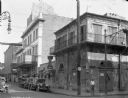
| Date: | 09 15 1928 |
|---|---|
| Description: | Street scene featuring the Old Absinthe House, a famous New Orleans establishment in the city's French Quarter. The building was built in 1806 by Pedro Fro... |
| Date: | |
|---|---|
| Description: | New Orleans street scene. Pedestrians can be seen on the sidewalks, and a streetcar can be seen in the distance. "Moskau Cabinet Works, door and window scr... |
| Date: | |
|---|---|
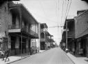
| Description: | Royal Street view toward an intersection of the French Quarter. Store signs displayed read: "The Model Store"; "Hats"; and "Peretti". |
| Date: | |
|---|---|
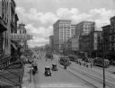
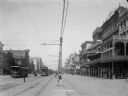
| Description: | Elevated view of Canal Street scene. Automobiles, streetcars and pedestrians are moving along the busy street. Store sign reads: "Stein-Block LAZARD'S Smar... |
| Date: | 1906 |
|---|---|
| Description: | View down Canal Street in New Orleans. View is toward the lake from Camp/Chartres Streets. The first building on the right reads "May's Drug Store". The tw... |
| Date: | |
|---|---|
| Description: | View of colonnade and French market. Pineapples and bananas are hanging in the stalls and in the foreground near a column. |
| Date: | |
|---|---|
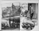
| Description: | Composite of views of New Orleans, including French quarter, market, collonade, locksmith, and tin fix. Text accompanying the views reads: "Vegetable Carts... |
| Date: | |
|---|---|
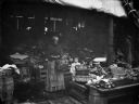
| Description: | A woman and two young children are shown in a farm market. |
| Date: | |
|---|---|
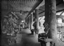
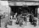
| Description: | View of shoppers in the French market. One boy is shown pushing two small children in a cart. Fruits and vegetables can be seen in the market stall in the ... |

| Date: | |
|---|---|
| Description: | Harold Gauer, Robert Bloch, and an unidentified man holding a cigarette, stand in front of an open doorway in a weathered building. Around the entrance is ... |

| Date: | |
|---|---|
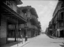
| Description: | View down Nicholas and Royal Streets. Men stand on the sidewalk near a cafe and lunch room. |

| Date: | |
|---|---|
| Description: | View down sidewalk on left side of Royal Street featuring two men near a market on the right. An iron fence is on the left side of the street. |

| Date: | 1759 |
|---|---|
| Description: | Map of New Orleans at the start of the French & Indian War, including two inset maps entitled "The Course of the Mississipi River from Bayagoulas to the Se... |

| Date: | 1769 |
|---|---|
| Description: | Map of New Orleans at the start of the French & Indian War, including two inset maps of the Mississippi River Delta and Fort la Balise. It shows streets, r... |

| Date: | 1761 |
|---|---|
| Description: | Map of New Orleans with north oriented towards the upper right corner. It shows the land around the city, the Mississippi River, anchorages, roads leading ... |
If you didn't find the material you searched for, our Library Reference Staff can help.
Call our reference desk at 608-264-6535 or email us at: