 Filter: Categories of Wisconsin Historical Images
Filter: Community of Neenah
Filter: Subject of transportation
Filter: Subject of water
Filter: Categories of Wisconsin Historical Images
Filter: Community of Neenah
Filter: Subject of transportation
Filter: Subject of water
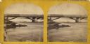
| Date: | 1870 |
|---|---|
| Description: | Stereograph view of Cedar Street Bridge(?) with a rocky shoreline on the left. The construction of this bridge is the same as the Cedar Street bridge, but ... |
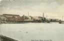
| Date: | 1910 |
|---|---|
| Description: | View of the Fox River with power plants and paper mills. Caption reads: "Water Power Plants, Neenah, Wis." |
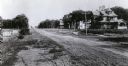
| Date: | |
|---|---|
| Description: | Looking east on Park Row, with several large buildings lining the right side of the street. Smaller buildings are near a shoreline on the left. |
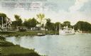
| Date: | |
|---|---|
| Description: | Lithograph of Riverside Park depicting people, boats, horses and buggies, steamboats in and around body of water. |
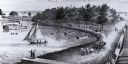
| Date: | 1908 |
|---|---|
| Description: | View from shoreline towards a large boat, perhaps an excursion boat, and sailboats docked further down along the curving shoreline. Beyond the boats is a t... |
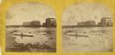
| Date: | 1870 |
|---|---|
| Description: | Stereograph view of the flour mill district. The Cedar Street Bridge is in the background, and the mills are, right to left going back, the Winnebago Flour... |

| Date: | 1870 |
|---|---|
| Description: | Stereograph of flour mill district. The Walnut Street bridge is in the background and the mill to the right is the Atlantic Mills (Neenah Stone Mills in 18... |
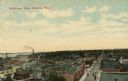
| Date: | 1915 |
|---|---|
| Description: | Elevated view of street and commercial buildings, and neighborhoods and a lake in the background. Caption reads: "Bird's-eye View, Neenah, Wis." |

| Date: | 1876 |
|---|---|
| Description: | This map is of the towns of Neenah and Menasha and shows existing and proposed canals. Water depths shown by soundings. Little Butte des Morts Lake, Doty I... |

| Date: | 1936 |
|---|---|
| Description: | This map of Neenah and Menasha shows some parks, churches, convention halls, and other buildings. These points of interest are in red ink. Streets, Little ... |

| Date: | 1846 |
|---|---|
| Description: | This plat map, which features the very early spelling of Wisconsin as "Wiskonsin", was created sometime between 1846 and 1854 and shows a canal and dam on ... |

| Date: | 1840 |
|---|---|
| Description: | This map shows a line of proposed construction for defending the north side of the canal against inundation from the Wisconsin River and location of Fort W... |
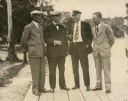
| Date: | 1930 |
|---|---|
| Description: | Four well-dressed gentlemen stand on a pier. A description of the photograph written by Ernst Schmidt reads: "This picture was undoubtedly taken at the 193... |

| Date: | 08 1927 |
|---|---|
| Description: | A description of this photograph provided by Ernst Schmidt reads: "The government river inspection boat with the 'Mystery' tied to her and the 'Bottoms Up'... |

| Date: | 08 1927 |
|---|---|
| Description: | Crew members are on their boats as they are towed into the harbor at Neenah after competing in the Inland Lake Yachting Association Regatta. Two other boat... |
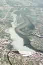
| Date: | 05 18 1970 |
|---|---|
| Description: | Aerial view titled "Neenah Pollution." The view is looking north from over Neenah at Little Lake Butte des Morts which is discolored. |
If you didn't find the material you searched for, our Library Reference Staff can help.
Call our reference desk at 608-264-6535 or email us at:
