 Filter: Categories of Wisconsin Historical Images
Filter: Community of Monroe
Filter: Year of 1800-1899
Filter: Subject of architecture
Filter: Categories of Wisconsin Historical Images
Filter: Community of Monroe
Filter: Year of 1800-1899
Filter: Subject of architecture

| Date: | 1871 |
|---|---|
| Description: | Birds eye map of Monroe, WI, depicts street names and street locations, houses, and trees. A reference key at the bottom of the map shows the locations of ... |
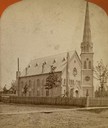
| Date: | 1890 |
|---|---|
| Description: | Exterior view of the First Methodist Episcopal Church, built in 1887. |
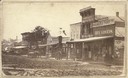
| Date: | 1870 |
|---|---|
| Description: | West side view of the Courthouse Square, with Hassinger & Chandler Dry Goods in the foreground. |
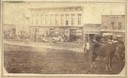
| Date: | 1870 |
|---|---|
| Description: | Southside view of the Monroe Courthouse Square with a horse in the foreground. |
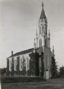
| Date: | 1861 |
|---|---|
| Description: | The First Universalist Church, built in 1861. |
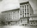
| Date: | 1872 |
|---|---|
| Description: | This photograph was made soon after the building was completed. It shows a five-leveled structure which was cut down to two and one-half levels in 1921. At... |
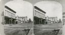
| Date: | 1880 |
|---|---|
| Description: | Stereograph view of the Westside Courthouse Square in Monroe. |

| Date: | 1861 |
|---|---|
| Description: | Shows townships and sections, landowners, and woodlands. Includes inset maps of Monroe, Brodhead, Albany, Cadiz, Decatur, Dayton, Clarence, Springfield, Tw... |

| Date: | 1857 |
|---|---|
| Description: | This map shows rural landownership and acreages, lot and block numbers, selected buildings, roads, railroads, and public squares. The map is indexed for th... |
If you didn't find the material you searched for, our Library Reference Staff can help.
Call our reference desk at 608-264-6535 or email us at: