 Filter: Categories of Wisconsin Historical Images
Filter: Community of Monroe
Filter: Subject of roads
Filter: Categories of Wisconsin Historical Images
Filter: Community of Monroe
Filter: Subject of roads

| Date: | 1871 |
|---|---|
| Description: | Birds eye map of Monroe, WI, depicts street names and street locations, houses, and trees. A reference key at the bottom of the map shows the locations of ... |
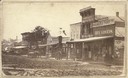
| Date: | 1870 |
|---|---|
| Description: | West side view of the Courthouse Square, with Hassinger & Chandler Dry Goods in the foreground. |
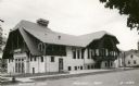
| Date: | 1940 |
|---|---|
| Description: | Turner Hall, a Swiss social center in Monroe. Caption reads: "Turner Hall, Monroe, Wis." |
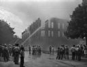
| Date: | 08 28 1948 |
|---|---|
| Description: | Spectators and fireman at the Fitzgibbons building fire downtown. |
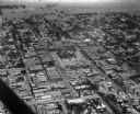
| Date: | 01 30 1949 |
|---|---|
| Description: | Aerial view of town, with a large building on a town square in the center. The edges of town are bordered by fields and farms. |

| Date: | 1969 |
|---|---|
| Description: | A map of the Elroy-Sparta State Trail and the surrounding area, showing the townships, the towns of Cashton, Sparta, in the west, and Union Center and Elro... |

| Date: | 1857 |
|---|---|
| Description: | This map shows rural landownership and acreages, lot and block numbers, selected buildings, roads, railroads, and public squares. The map is indexed for th... |
If you didn't find the material you searched for, our Library Reference Staff can help.
Call our reference desk at 608-264-6535 or email us at: