Filter: Categories of Wisconsin Historical Images
Filter: Community of Mineral Point
Filter: Year of 1900-1999
Filter: Year of 1920-1929
Filter: Categories of Wisconsin Historical Images
Filter: Community of Mineral Point
Filter: Year of 1900-1999
Filter: Year of 1920-1929
| Date: | 1925 |
|---|---|
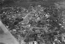
| Description: | Aerial photograph taken as part of a survey by the Wisconsin Power and Light Company to promote economic development by emphasizing available buildings and... |
| Date: | 1925 |
|---|---|
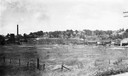
| Description: | Empty field with Mineral Point in the background taken as part of a survey by the Wisconsin Power and Light Company to promote economic development by emph... |
| Date: | 1925 |
|---|---|
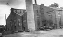
| Description: | Exterior shot of a vacant factory building with a car parked in front taken as part of a survey by the Wisconsin Power and Light Company to promote economi... |
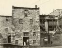
| Date: | 1925 |
|---|---|
| Description: | The rear facade of a cheese house. A man is standing in the doorway of the loading dock next to a hand cart. |
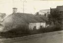
| Date: | 1925 |
|---|---|
| Description: | View from road looking down slope toward the house of a Cornish miner. Other buildings are in the background on the right. |
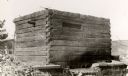
| Date: | 1925 |
|---|---|
| Description: | A roughly built jail, constructed before 1836. Vineyard would have been held here a short time before he was released on bail. |
| Date: | 1925 |
|---|---|
| Description: | The Knights of Pythias Castle Hall, formerly the Presbyterian Church, dedicated in 1844. The small building to the right of the church was built and occupi... |
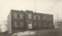
| Date: | 1925 |
|---|---|
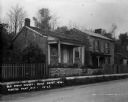
| Description: | Lower Ward School (also called Second Ward School) built in 1867 and used through 1923. It was torn down in 1931. |

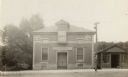
| Date: | 1920 |
|---|---|
| Description: | St. Paul's Irish Catholic Church, erected in 1855. |
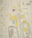
| Date: | 07 1929 |
|---|---|
| Description: | Sheet 10 of a Sanborn map of a portion of Mineral Point. |
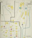
| Date: | 07 1929 |
|---|---|
| Description: | Sheet 9 of a Sanborn map of a portion of Mineral Point. |

| Date: | 1929 |
|---|---|
| Description: | View down High Street looking east. There are many automobiles parked along the curb, and shops line the street. At the end of the street down the hill is ... |

| Date: | 1929 |
|---|---|
| Description: | View across street of the three-story grade school. |

| Date: | 1929 |
|---|---|
| Description: | Two men and two women play a game of golf at the Blue Grass Country Club. One man tees off as the other three players watch. |
If you didn't find the material you searched for, our Library Reference Staff can help.
Call our reference desk at 608-264-6535 or email us at: