Filter: Categories of Wisconsin Historical Images
Filter: Community of Mineral Point
Filter: Subject of roads
Filter: Categories of Wisconsin Historical Images
Filter: Community of Mineral Point
Filter: Subject of roads
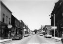
| Date: | 1960 |
|---|---|
| Description: | View of businesses on High Street, including the Rexall Drugstore on the left corner. One can also see a glimpse of the City Hall, directly across the stre... |
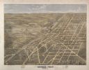
| Date: | 1872 |
|---|---|
| Description: | Bird's-eye map of Mineral Point, looking southeast. |
| Date: | 1925 |
|---|---|
| Description: | View from road looking down slope toward the house of a Cornish miner. Other buildings are in the background on the right. |

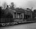
| Date: | 1932 |
|---|---|
| Description: | The home of Montgomery M. Cothren, erected in 1855. Cothren served as a delegate to the Territorial Legislature in 1847-1848 and was later elected to the S... |

| Date: | 1910 |
|---|---|
| Description: | Mineral Spring Brewery, located on 272 Shake Rag Street, erected in 1850 (currently 276 Shake Rag Street). A group of four men are posing outdoors on the r... |
| Date: | 1870 |
|---|---|
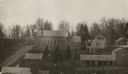
| Description: | View over rooftops towards the primitive Methodist Church, which is surrounded by homes. |
| Date: | 1962 |
|---|---|
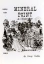
| Description: | A book cover for "Mineral Point: A History" by George Fiedler. The cover illustration is a Max Fernekes print of Shake Rag Street, a popular street for Cor... |

| Date: | 1905 |
|---|---|
| Description: | A watertower in Mineral Point. Caption reads: "Watertower, Mineral Point, Wis." |
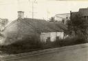
| Date: | |
|---|---|
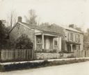
| Description: | On Shakerag Street. Two houses, both of stone, behind a wood fence and a low stone wall along a sidewalk. The house on the right is two stories, the left ... |
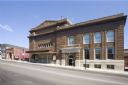
| Date: | 2009 |
|---|---|
| Description: | Exterior view of Mineral Point Opera House and City Hall from across the street. |

| Date: | 1836 |
|---|---|
| Description: | This early to mid-19th century map shows the township and range system, sections, landownership, furnaces, lead mines, copper mines, and roads in the vicin... |

| Date: | 1900 |
|---|---|
| Description: | View looking down hill of open, grassy fields and houses on a hill in the distance. At the bottom of the hill in the foreground is a stream running through... |

| Date: | |
|---|---|
| Description: | A vintage view and a modern view of a stone Methodist Episcopal Church, which was dedicated in 1871. |
If you didn't find the material you searched for, our Library Reference Staff can help.
Call our reference desk at 608-264-6535 or email us at: