 Filter: Categories of Wisconsin Historical Images
Filter: Community of Mineral Point
Filter: Subject of cities and towns
Filter: Type of Map or Atlas
Filter: Categories of Wisconsin Historical Images
Filter: Community of Mineral Point
Filter: Subject of cities and towns
Filter: Type of Map or Atlas
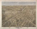
| Date: | 1872 |
|---|---|
| Description: | Bird's-eye map of Mineral Point, looking southeast. |

| Date: | 1840 |
|---|---|
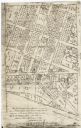
| Description: | A hand-drawn plat map of Mineral Point, Wisconsin showing street layout and location of buildings. |
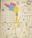
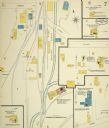
| Date: | 1900 |
|---|---|
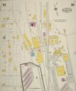
| Description: | Sanborn map of Mineral Point, sheet 1. |
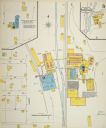
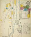
| Date: | 1900 |
|---|---|
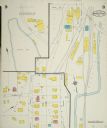
| Description: | Sanborn map, sheet 5, of a portion of Mineral Point. |
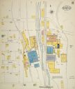
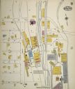
| Date: | 08 1908 |
|---|---|
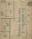
| Description: | Sanborn map of a portion of Mineral Point. |
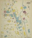
| Date: | 1908 |
|---|---|
| Description: | Sanborn map, sheet 7, of a portion of Mineral Point. |
| Date: | 09 1915 |
|---|---|
| Description: | Sheet 1 of a Sanborn map of a portion of Mineral Point. |
| Date: | 09 1915 |
|---|---|
| Description: | Sheet 8 of a Sanborn map of a portion of Mineral Point. |
| Date: | 09 1915 |
|---|---|
| Description: | Sheet 7 of a Sanborn map of a portion of Mineral Point. |
| Date: | 07 1929 |
|---|---|
| Description: | Sheet 10 of a Sanborn map of a portion of Mineral Point. |
| Date: | 07 1929 |
|---|---|
| Description: | Sheet 9 of a Sanborn map of a portion of Mineral Point. |
| Date: | 08 1884 |
|---|---|
| Description: | Sheet 1 of a Sanborn map of a portion of Mineral Point. |

| Date: | 08 1884 |
|---|---|
| Description: | Sheet 2 of a Sanborn map of a portion of Mineral Point. |

| Date: | 04 1889 |
|---|---|
| Description: | Sheet 1 of a Sanborn map of a portion of Mineral Point. |

| Date: | 04 1889 |
|---|---|
| Description: | Sheet 2 of a Sanborn map of a portion of Mineral Point. |

| Date: | 04 1889 |
|---|---|
| Description: | Sheet 4 of a Sanborn map of a portion of Mineral Point. |

| Date: | 07 1894 |
|---|---|
| Description: | Sheet 5 of a Sanborn map of a portion of Mineral Point. |

| Date: | 1836 |
|---|---|
| Description: | This early to mid-19th century map shows the township and range system, sections, landownership, furnaces, lead mines, copper mines, and roads in the vicin... |

| Date: | 1856 |
|---|---|
| Description: | This map of Woodman's Addition in Mineral Point is pen-and-ink on paper. The map includes certifications signed by John B. Whitelaw (surveyor), Cyrus Woodm... |
| Date: | 1900 |
|---|---|
| Description: | This facsimile of manuscript map shows lot numbers, dimensions, streets, and township lines. The bottom left corner includes a certification. |
If you didn't find the material you searched for, our Library Reference Staff can help.
Call our reference desk at 608-264-6535 or email us at: