 Filter: Categories of Wisconsin Historical Images
Filter: Community of Menomonie
Filter: Subject of transportation
Filter: Categories of Wisconsin Historical Images
Filter: Community of Menomonie
Filter: Subject of transportation
| Date: | |
|---|---|
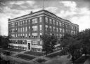
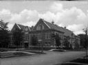
| Description: | Elevated view of the five-story Home Economics Building at the Stout Institute (now University of Wisconsin-Stout). Automobiles park alongside the streets ... |
| Date: | |
|---|---|
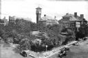
| Description: | Elevated view of buildings on the Stout Institute campus (now the University of Wisconsin-Stout). The buildings include a clock tower and are located on a... |
| Date: | |
|---|---|
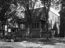
| Description: | Exterior view of the Mabel Tainter Memorial, a Wisconsin State historic site built in 1889. The design was intended to reflect the Richardsonian Romanesque... |
| Date: | |
|---|---|
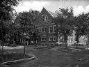
| Description: | View of Bertha Tainter Hall, a building at the Stout Institute (now the University of Wisconsin-Stout). The Victorian-style building features a front porch... |
| Date: | |
|---|---|
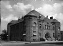
| Description: | View of the Gymnasium at the University of Wisconsin-Stout, a brick building bordered by an intersection. Several men stand at the building's entrance. |
| Date: | |
|---|---|
| Description: | A group of men stand on a sidewalk in front of the entrance to the multi-story brick gymnasium building at the University of Wisconsin-Stout. Two automobil... |
| Date: | |
|---|---|
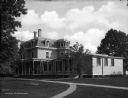
| Description: | View of Lynwood Hall (?) at the University of Wisconsin-Stout. The brick building features an enclosed porch, balcony, and stairs leading up to the front ... |

| Date: | 1932 |
|---|---|
| Description: | View from shoreline of three men in a canoe on Lake Menomin near a point of land. |

| Date: | 1932 |
|---|---|
| Description: | Two cars are parked in a grove of trees; people sit at a picnic table in the background. There are other tables in the area, as well as benches and a trash... |
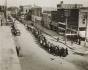
| Date: | 11 11 1918 |
|---|---|
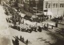
| Description: | Elevated view from building of informal Armistice Day street parade at an intersection of the downtown area. They are celebrating the conclusion of the fir... |
| Date: | 11 11 1918 |
|---|---|
| Description: | Elevated view from building of informal Armistice Day street parade at an intersection of the downtown area. They are celebrating the conclusion of the fir... |
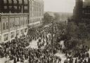
| Date: | 05 21 1919 |
|---|---|
| Description: | Elevated view of street entertainment, with crowds, dancing and band concert to welcome home Wisconsin National Guard, 3d Regiment, Company H, after servic... |

| Date: | 1960 |
|---|---|
| Description: | This map shows lot and block numbers, additions, and rural acreages and includes an index of rail roads, industrial plants, Dunn County and Menominee owned... |

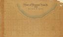
| Date: | 1859 |
|---|---|
| Description: | This plat map is pen on paper and shows numbered blocks and lots, local streets, and section lines. Also included is text on survey certifications. |

| Date: | 1859 |
|---|---|
| Description: | This plat map is pen on paper and shows numbered blocks and lots, local streets, and section lines. Also included is text on survey certifications. The top... |
| Date: | |
|---|---|
| Description: | This plat map is pen, pencil, and watercolor on paper and shows numbered blocks and lots, local streets, section lines, the public square, Mill pond, and l... |

| Date: | 1875 |
|---|---|
| Description: | This plat map shows local streets, buildings, numbered blocks and lots, part of the Red Cedar River, and land ownership by name. Also included is a busines... |

| Date: | 1896 |
|---|---|
| Description: | This map shows plat of town, local streets, numbered blocks and lots, mill pond, mills, part of the Red Cedar River, and land and property ownership by nam... |

| Date: | 1911 |
|---|---|
| Description: | This map shows plat of town, local streets, numbered lots, blocks, and wards, roads, Lake Menomin, Wilson Creek, Red Cedar River, and land ownership by nam... |

| Date: | 1907 |
|---|---|
| Description: | This blueprint map shows a proposed plan for pleasure roads and reservation system. It also shows schools, cemeteries, old river channel, proposed bridge, ... |
If you didn't find the material you searched for, our Library Reference Staff can help.
Call our reference desk at 608-264-6535 or email us at: