 Filter: Categories of Wisconsin Historical Images
Filter: Community of Menomonie
Filter: Subject of bridges
Filter: Categories of Wisconsin Historical Images
Filter: Community of Menomonie
Filter: Subject of bridges
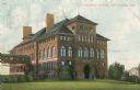
| Date: | 1905 |
|---|---|
| Description: | The Central School building is attached to the Bowman Building by a second-story bridge on the left. Caption reads: "Central School Menomonie, Wis." |
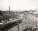
| Date: | 1899 |
|---|---|
| Description: | Elevated view looking north towards Menomonie, the Knapp, Stout and Company lumber mills. |

| Date: | 1910 |
|---|---|
| Description: | Elevated view across rooftops towards the dam on the Red Cedar River, also showing the electric power plant and mills. Caption reads: "Lake and Falls, Meno... |

| Date: | 1908 |
|---|---|
| Description: | Elevated view of the dam on the Red Cedar River, also showing the electric power plant and mills. Caption reads: "Bridge, Falls, Electric Power House and t... |
| Date: | 1915 |
|---|---|
| Description: | The Central School, later a part of Stout State College. Caption reads: "Central School, Menomonie, Wis." |

| Date: | |
|---|---|
| Description: | A wooden footbridge crosses Wilson Creek in a wooded area. |

| Date: | |
|---|---|
| Description: | A railroad bridge crosses over Red Cedar River. |

| Date: | |
|---|---|
| Description: | View of an arch bridge over the Red Cedar River. Forested shorelines surround the water. |

| Date: | |
|---|---|
| Description: | View of a rustic wooden bridge running through a forested area. The bridge features a walkway with railings on both sides. |

| Date: | |
|---|---|
| Description: | A creek runs beneath the stone underpass of Clove Bridge. Trees, logs, and foliage surrounding the structure. |

| Date: | |
|---|---|
| Description: | A river passes beneath a truss bridge. City buildings are visible on the opposite side of the structure. |
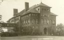
| Date: | |
|---|---|
| Description: | View of Central School. The brick building features arch windows and two chimneys. An enclosed bridge connects the building to another beside it and tree... |
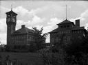
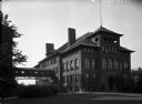
| Date: | |
|---|---|
| Description: | Exterior view of the manual training buildings at the Stout Institute (now the University of Wisconsin-Stout) seen from across the campus lawn. The two bri... |

| Date: | 1907 |
|---|---|
| Description: | This blueprint map shows a proposed plan for pleasure roads and reservation system. It also shows schools, cemeteries, old river channel, proposed bridge, ... |

| Date: | 1908 |
|---|---|
| Description: | The high school building. A pedestrian bridge is on the left side of the building. Caption reads: "Central School, Menomonie, Wis." |

| Date: | |
|---|---|
| Description: | Central High School and Stout Manual Training School connected by pedestrian bridge. Two men are walking on the lawn towards the buildings. Caption reads: ... |

| Date: | 1957 |
|---|---|
| Description: | Elevated view between trees of Lake Menomin and a bridge. There are buildings among trees in the distance. Caption reads: "Lake Menomin, Menomonie, Wis." |
| Date: | 1910 |
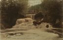
|---|---|
| Description: | View looking up toward a waterfall with a footbridge spanning the top. A man is on the bridge. Caption reads: "Lambs Creek Falls near Menomonie, Wis." |

| Date: | |
|---|---|
| Description: | View of a highway bridge spanning the Red Cedar River, and a road along the far shoreline. Caption reads: "U.S. Hy 12 New Bridge, Menomonie, Wis." |

| Date: | 1932 |
|---|---|
| Description: | View of a footbridge over a stream in the woods. Caption reads: "Rustic Bridge, Menomonie, Wis." |
If you didn't find the material you searched for, our Library Reference Staff can help.
Call our reference desk at 608-264-6535 or email us at: