 Filter: Categories of Wisconsin Historical Images
Filter: Community of Marinette
Filter: Year of 1800-1899
Filter: Categories of Wisconsin Historical Images
Filter: Community of Marinette
Filter: Year of 1800-1899
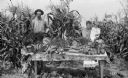
| Date: | 09 05 1895 |
|---|---|
| Description: | Matthew H. Stephenson, his wife Julia Hebert Stephenson, and their son William Clinton pose with vegetables from the Menomonee River Boom Company garden ne... |

| Date: | 1881 |
|---|---|
| Description: | Bird's-eye map of Marinette, with insets. |
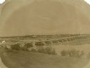
| Date: | 1870 |
|---|---|
| Description: | View from shoreline over river towards the town. |
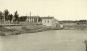
| Date: | 1887 |
|---|---|
| Description: | View of the boom company office and the site of the old trading post. |

| Date: | 1887 |
|---|---|
| Description: | Elevated view of Marinette looking toward the mouth of the river from the tower of City Hall. Fences, fields, and industrial buildings are in the foregroun... |
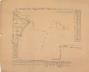
| Date: | 1856 |
|---|---|
| Description: | Shows sections and acreages. Covers portions of the area now occupied by Marinette and the Town of Peshtigo, Marinette County. "Rec’d Sept. 24 with Sur. Ge... |
If you didn't find the material you searched for, our Library Reference Staff can help.
Call our reference desk at 608-264-6535 or email us at: