 Filter: Categories of Wisconsin Historical Images
Filter: Community of Manitowoc
Filter: Subject of water
Filter: Categories of Wisconsin Historical Images
Filter: Community of Manitowoc
Filter: Subject of water
| Date: | |
|---|---|
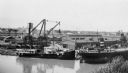
| Description: | Elevated view across river of the S.S. Hyacinth of the U.S. Lighthouse Service being repaired at the Manitowoc Ship Building Company dock. The Fr... |
| Date: | 1888 |
|---|---|
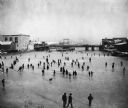
| Description: | Elevated view of a winter scene with a large group of people skating on the frozen Manitowoc River between the 8th and 10th Street bridges. A dog trots acr... |
| Date: | 06 1939 |
|---|---|
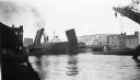
| Description: | Bridge on the Manitowoc River raised to allow the Pere Marquette car ferry through. River dredging equipment can be seen in the foreground. |
| Date: | 1900 |
|---|---|
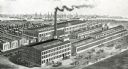
| Description: | Engraved bird's-eye view of the wood shop, warehouse, machine shop, dry kilns, and foundry of the Manitowoc Seating Company. Several people pass in front o... |
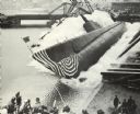
| Date: | 05 10 1942 |
|---|---|
| Description: | USS "Peto" (SS-265), a Gato-class submarine, was a ship of the United States Navy named for the peto, a sharp-nosed tropical fish of the mackerel family. "... |

| Date: | |
|---|---|
| Description: | Letterhead of the William Rahr Sons' Company of Manitowoc, Wisconsin, "Maltsters and Roasters," with an elevated view of the company building on one side o... |
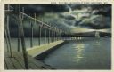
| Date: | 1927 |
|---|---|
| Description: | Hand-colored postcard view of a pier and lighthouse at night. The moon shines through clouds, and light shines in two directions from the beacon on top of ... |
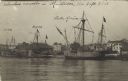
| Date: | 09 06 1913 |
|---|---|
| Description: | Postcard view across water towards reproductions of Christopher Columbus' ships, the Niña, Pinta, and the Santa Maria docked at Manito... |

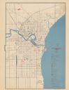
| Date: | 01 1899 |
|---|---|
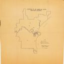
| Description: | Shows lot and block numbers, railroads, ward boundaries, and some landownership. Includes public building index. |
| Date: | 1945 |
|---|---|
| Description: | Map features a legend with symbols of points of interest. The symbols are in red. The back of the map has text on "Points of Interest and Information". |

| Date: | 1951 |
|---|---|
| Description: | Water depths shown by bathymetric tints, isolines, and soundings. Relief shown by contours. "Soundings in feet." "Aids to navigation corrected to May 4, 19... |

| Date: | 1950 |
|---|---|
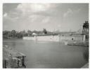
| Description: | Aerial view showing shipyards, rivers and roads. |
| Date: | 10 1962 |
|---|---|
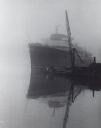
| Description: | Lake steamer at dock, in fog. To the right is the boom of a crane. In front of the steamer is a tugboat. |
| Date: | 07 02 1960 |
|---|---|
| Description: | View across water towards the Manitowoc Shipbuilding floating drydock. Pilings and grass are in the foreground. On the far shoreline are buildings on a hil... |

| Date: | 01 08 1958 |
|---|---|
| Description: | Elevated view from 8th Street Bridge over the Manitowoc River towards Lake Michigan. There is a lighthouse in the distance. Ice is floating on the water. A... |

| Date: | 01 08 1958 |
|---|---|
| Description: | Elevated view over icy water towards ships in the shipyard on the left, and the cement company in the background. Cranes and industrial buildings are in th... |

| Date: | 1905 |
|---|---|
| Description: | This map shows a plat of the city, local streets, railroads, public buildings, local businesses, and parts of the Manitowoc River and Lake Michigan. Relief... |

| Date: | |
|---|---|
| Description: | This plat map shows numbered blocks and lots, wards, local streets, railroads, cemeteries, buildings, land ownership by name, and parts of Manitowoc River ... |

| Date: | 1925 |
|---|---|
| Description: | This map shows a plat of the city, local streets, railroads, public buildings, local businesses, and parts of the Manitowoc River and Lake Michigan. Relief... |
| Date: | 08 1964 |
|---|---|
| Description: | This map shows the city limits, Lake Michigan, the Manitowoc River, Silver Creek, designated sample sites with manuscript annotations, central business dis... |
If you didn't find the material you searched for, our Library Reference Staff can help.
Call our reference desk at 608-264-6535 or email us at: