 Filter: Categories of Wisconsin Historical Images
Filter: Community of Madison
Filter: Type of Map or Atlas
Filter: Categories of Wisconsin Historical Images
Filter: Community of Madison
Filter: Type of Map or Atlas
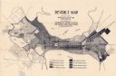
| Date: | 1923 |
|---|---|
| Description: | This map shows local streets, parks, Lake Wingra, and parts of Lake Mendota and Lake Monona. The map includes a legend showing residential, commercial, lig... |

| Date: | 1926 |
|---|---|
| Description: | This map is oriented with the north to the upper right and shows a plat of the area, numbered blocks, lots, and wards, land ownership by name, local street... |

| Date: | 1929 |
|---|---|
| Description: | This is a blue line print map that shows local streets, railroads, local businesses, schools, parks, cemeteries, the airport, the state capitol, the Univer... |

| Date: | 1932 |
|---|---|
| Description: | This map shows local streets, section lines, Nakoma Country Club, part of Lake Forest, and part of Lake Wingra. The map includes a legend showing areas of ... |

| Date: | |
|---|---|
| Description: | A decorative map of Fuller's Woods development along the Lake Mendota shoreline. Includes numbered lots and building line setbacks with decorative features... |

| Date: | 1902 |
|---|---|
| Description: | Madison Sanborn map, including Langdon and State Streets. |

| Date: | 1908 |
|---|---|
| Description: | A detail of a Madison Sanborn map that includes the University of Wisconsin Boat House, UW Gymnasium & Armory (The Red Gym), fraternity houses, and the YMC... |

| Date: | 1906 |
|---|---|
| Description: | This map shows shows streets, subdivisions, railroads, places of interest including the State Capitol, the University of Wisconsin, Camp Randall, Henry Vil... |

| Date: | 1856 |
|---|---|
| Description: | This map is ink and watercolor on tracing paper and shows plat of city, local streets, block numbers, topography, several buildings, and includes an explan... |
| Date: | 04 1904 |
|---|---|
| Description: | This map is pen and pencil on paper and shows local streets, and the following University of Wisconsin-Madison buildings: the Main Hall, South Hall, North ... |

| Date: | 1918 |
|---|---|
| Description: | This is a collection of two maps. One map is blue line print that includes illustrations and shows the location of buildings, gardens, plant life, and spri... |

| Date: | 1924 |
|---|---|
| Description: | This pictorial map focuses on the Madison Isthmus, Lake Mendota, Lake Monona, Lake Wingra, and shows points of historical interest, buildings, parks, and I... |

| Date: | 1920 |
|---|---|
| Description: | This blue print map and blue line print copy mounted on cloth shows land ownership by name, campus buildings, local streets, railroads, and part of Lake Me... |

| Date: | 1924 |
|---|---|
| Description: | Intended for tourists, this brochure, titled: "Plan Now to See Madison, The Four Lake City: "The City Built on an Isthmus," features a map of Madison and s... |

| Date: | 1921 |
|---|---|
| Description: | This map has labeled streets and points of interest. Lake Mendota and Lake Monona are labeled. The back of the map includes index of University of Wisconsi... |

| Date: | 1929 |
|---|---|
| Description: | This map includes illustrations and shows campus buildings, points of interest in the surrounding area, railroads, Lake Mendota and Lake Monona. The back o... |

| Date: | 1914 |
|---|---|
| Description: | This map shows plat of the town, city limits, numbered blocks and lots, wards, local streets, roads, railroads, Capitol Square, Vilas Park, Edgewood Academ... |

| Date: | 1914 |
|---|---|
| Description: | This map shows a plat of the town, city limits, numbered blocks and lots, wards, local streets, roads, railroads, Capitol Square, Vilas Park, Edgewood Acad... |

| Date: | 1933 |
|---|---|
| Description: | Blue print and blue line print maps that show local streets, Nakoma Country Club, part of Lake Forest, and part of Lake Wingra. A legend is included that s... |

| Date: | 1938 |
|---|---|
| Description: | This map is blue line print and shows local streets, roads, the University of Wisconsin, Monona Village, Verona, Middleton, McFarland, Lake Mendota, Lake M... |
If you didn't find the material you searched for, our Library Reference Staff can help.
Call our reference desk at 608-264-6535 or email us at: