| Date: | 1900 |
|---|---|
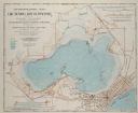
| Description: | Hydrographic map of Lake Mendota and it's adjacent topography. Prepared from surveys made by civil engineering students, University of Wisconsin, classes 1... |

| Date: | 1900 |
|---|---|
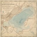
| Description: | A hydrographic map of Lake Monona and the adjacent topography. |

| Date: | 1920 |
|---|---|
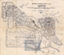
| Description: | This map shows a plat of the area, numbered blocks and lots, local streets, roads, parks, Nakoma Country Club golf course, and landscaping. The map is orie... |

| Date: | 1920 |
|---|---|
| Description: | This map, with north oriented to the right, shows a plat of the area, numbered blocks and lots, local streets, roads, parks, a proposed golf course, and la... |

| Date: | 05 1916 |
|---|---|
| Description: | This manuscript blueprint map includes street names, certifications, registration, and tables of curve data. |

| Date: | 1915 |
|---|---|
| Description: | This manuscript blueprint map oriented with north to the upper right. The map includes street names, certifications, and registration. Streets left to righ... |

| Date: | 11 1915 |
|---|---|
| Description: | This manuscript blueprint shows streets and includes certifications and registration. The streets running left to right are: Wenonah Drive, Wanda Place, Na... |
If you didn't find the material you searched for, our Library Reference Staff can help.
Call our reference desk at 608-264-6535 or email us at: