 Filter: Categories of Wisconsin Historical Images
Filter: Community of La Crosse
Filter: Year of 1800-1899
Filter: Categories of Wisconsin Historical Images
Filter: Community of La Crosse
Filter: Year of 1800-1899
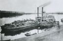
| Date: | 1875 |
|---|---|
| Description: | View down hill towards "Diamond Jo" steamboat docked on the shoreline of the Mississippi River while goods are being loaded onto the steamboat. |
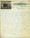
| Date: | 1887 |
|---|---|
| Description: | Letterhead of the La Crosse Wallis Carriage Co., manufacturers of fine family carriages, showing a view of the factory with the Mississippi River in the ba... |
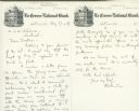
| Date: | 1889 |
|---|---|
| Description: | Letterhead stationery of the La Crosse National Bank, with an engraved image of the bank building at the top. |

| Date: | 1898 |
|---|---|
| Description: | Caption reads, "Sam D. Conant at cottage." A woman sits on the boardwalk and looks at the child. |
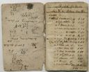
| Date: | 1841 |
|---|---|
| Description: | Inside front cover and first page of Nathan Myrick's 1841-1842 account book showing his purchase of supplies at Prairie du Chien for the establishment of h... |
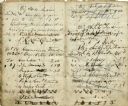
| Date: | 1841 |
|---|---|
| Description: | Page from Nathan Myrick's account book showing transactions with Native Americans. |
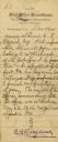
| Date: | 1891 |
|---|---|
| Description: | Letter from Fourth Assistant Postmaster General, Estes G. Rathbone, regarding the establishment of the Post Office at La Crosse and Nathan Myrick's appoint... |

| Date: | 1890 |
|---|---|
| Description: | A large group of Brewery workers posing outside of Gund's Brewery in La Crosse. In the front of the group two men are seated at a table with a large stein ... |

| Date: | 1873 |
|---|---|
| Description: | A map that covers parts of Winona and Houston Counties, Minnesota and La Crosse County, Wisconsin, showing the proposed railroad routes, constructed rail l... |

| Date: | 12 02 1885 |
|---|---|
| Description: | Fringed red silk overlay cover and gold silk ribbon backed menu page, sewn at top, for a "Complimentary Banquet to Hon. Wm. F. Cody, (Buffalo Bill) by his ... |

| Date: | 1856 |
|---|---|
| Description: | This map of the City of La Crosse is a plat of Pike & Co's Addition. The map shows street names, block and lot numbers, the South La Crosse River, and the ... |

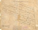
| Date: | 1870 |
|---|---|
| Description: | This map of the Village of North La Crosse is partially hand-drawn and includes text about the land in the lower margin. |

| Date: | 1874 |
|---|---|
| Description: | This map of La Crosse is accompanied by other plats of subdivision of the city. The relief is shown by hachures. The additions include: Rudolf Gripps Addit... |

| Date: | 1880 |
|---|---|
| Description: | This map of La Crosse shows the Chicago, Milwaukee and St. Paul Railroad, the Southern Minnesota Railroad and the Chicago, Dubuque and Minnesota Railroad, ... |

| Date: | 1891 |
|---|---|
| Description: | This map of La Crosse shows eighteen city wards in red, railroads, cemeteries, fair grounds, labeled streets, islands, and the Mississippi River. The left ... |

| Date: | 1893 |
|---|---|
| Description: | This map of La Crosse shows city ward boundaries in red, streets, railroads, cemeteries, Grand station crossing, the road to French Island, depots, Lake Pa... |

| Date: | 1893 |
|---|---|
| Description: | This map of La Crosse shows wards 1-20, streets, railroads, the Inter State Fair Grounds, islands, and the Mississippi River. Relief is shown by hachures. ... |
| Date: | 1840 |
|---|---|
| Description: | This map of La Crosse is ink and pencil on paper and shows lot and block numbers, as well as buildings. An inscription on the bottom of the map reads: "Tim... |

| Date: | 1880 |
|---|---|
| Description: | This map of the southern part of La Crosse is pen on cloth and shows proposed streets crossing the lands of Jane Usher and the Green Bay, Winona and St. Pa... |

| Date: | 1857 |
|---|---|
| Description: | This map show city plats including the name and number of the plats as well as some land ownership. Some of the plats have manuscript annotations outlined ... |
If you didn't find the material you searched for, our Library Reference Staff can help.
Call our reference desk at 608-264-6535 or email us at: