 Filter: Categories of Wisconsin Historical Images
Filter: Community of La Crosse
Filter: Year of 1800-1899
Filter: Subject of streets
Filter: Year of 1880-1889
Filter: Categories of Wisconsin Historical Images
Filter: Community of La Crosse
Filter: Year of 1800-1899
Filter: Subject of streets
Filter: Year of 1880-1889
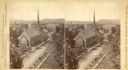
| Date: | 1880 |
|---|---|
| Description: | Stereograph of an elevated view of the Congregational Church. View is from the high school looking down Main Street. |

| Date: | 1880 |
|---|---|
| Description: | This map of the southern part of La Crosse is pen on cloth and shows proposed streets crossing the lands of Jane Usher and the Green Bay, Winona and St. Pa... |

| Date: | 1886 |
|---|---|
| Description: | This map has relief shown by hachures and includes a list of plats in order of date of record, laws which vacate plats, plats not shown as upon the county ... |

| Date: | 1888 |
|---|---|
| Description: | This map has relief shown by hachures and features inset maps of a plat of E.D. Clinton and Blackwell’s add’n to the City of La Crosse. Wards (1-10) shaded... |

| Date: | 1883 |
|---|---|
| Description: | This map shows ward boundaries, names of additions, streets, bridges, mills, schools, religious buildings, businesses, hotels, railroads, factories, brewer... |
If you didn't find the material you searched for, our Library Reference Staff can help.
Call our reference desk at 608-264-6535 or email us at: