 Filter: Categories of Wisconsin Historical Images
Filter: Community of La Crosse
Filter: Year of 1800-1899
Filter: Subject of land
Filter: Categories of Wisconsin Historical Images
Filter: Community of La Crosse
Filter: Year of 1800-1899
Filter: Subject of land
| Date: | 1800 |
|---|---|
| Description: | This map show a plat and covers the area bordered by Main to King streets and from 15th to 17th streets. |

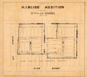
| Date: | 10 1891 |
|---|---|
| Description: | This blueprint map shows land ownership and buildings. Text below the title reads: "The La Crosse Heights include the ridge of land with the spurs projecti... |
If you didn't find the material you searched for, our Library Reference Staff can help.
Call our reference desk at 608-264-6535 or email us at: