Filter: Categories of Wisconsin Historical Images
Filter: Community of La Crosse
Filter: Subject of land
Filter: Creator Name of Unknown
Filter: Categories of Wisconsin Historical Images
Filter: Community of La Crosse
Filter: Subject of land
Filter: Creator Name of Unknown

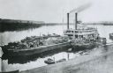
| Date: | 1868 |
|---|---|
| Description: | The sidewheel packet, Keokuk, loaded with passengers beside a barge at a landing. The landing is filled with people and horse-drawn vehicles. The si... |
| Date: | 1910 |
|---|---|
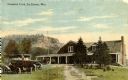
| Description: | View up dirt road toward club. Automobiles are parked on the left. There is a bluff in the background. Caption reads: "Country Club, La Crosse, Wis." |
| Date: | 1901 |
|---|---|
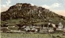
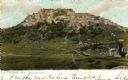
| Description: | Grand Dad Bluff in La Crosse with the Crusher building which was built in 1901 and burned in 1902. Caption reads: "Grand Dad Bluff, La Crosse, Wis." |
| Date: | |
|---|---|
| Description: | Colorized view of Ebner's Coulee. Caption reads: "Ebner's Coulee, taken from Grandad Bluff, La Crosse, Wis." |
| Date: | |
|---|---|
| Description: | Aerial view of La Crosse, with the Mississippi River in the distance. |

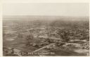
| Date: | 1900 |
|---|---|
| Description: | Elevated view of La Crosse. Caption reads: "Panorama of La Crosse, Wis. from Grand Dad's Bluff." |
| Date: | 1875 |
|---|---|
| Description: | View down hill towards "Diamond Jo" steamboat docked on the shoreline of the Mississippi River while goods are being loaded onto the steamboat. |
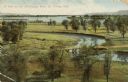
| Date: | 1909 |
|---|---|
| Description: | Elevated view of winding tributaries leading to Mississippi River. A road passes over a bridge in the foreground. Caption reads: "A View on the Mississippi... |
| Date: | |
|---|---|
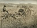
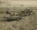
| Description: | Man sitting behind a La Crosse tractor on a thresher. |

| Date: | |
|---|---|
| Description: | View across plowed field of group of employees of La Crosse Tractor? The men are wearing long jackets, neckties, gloves, and hats. In the background are fa... |
| Date: | |
|---|---|
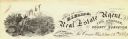
| Description: | Letterhead of H.I. Bliss, a real estate agent, civil engineer, and county surveyor in La Crosse, Wisconsin. On the left a group of three men are surveying ... |

| Date: | 1893 |
|---|---|
| Description: | This map of La Crosse shows wards 1-20, streets, railroads, the Inter State Fair Grounds, islands, and the Mississippi River. Relief is shown by hachures. ... |

| Date: | 1940 |
|---|---|
| Description: | This map of La Crosse shows different types of land zoning: residence, multiple dwelling, local business, commercial, light industrial, heavy industrial, w... |

| Date: | 1900 |
|---|---|
| Description: | The map is watercolor, pencil, and ink on tracing cloth and shows plats of both cities, local streets, railroads, mills, township divisions, bridges, and p... |
| Date: | 1936 |
|---|---|
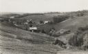
| Description: | View down hill towards valley of farming country in the “Coulee Region.” |

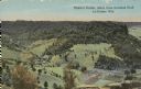
| Date: | 04 09 1936 |
|---|---|
| Description: | The Buffalo Head, a 'native' stone sculpture by the Mississippi River at the junction of Flint Ledge and Indian trails in Wyalusing State Park. The verso... |

| Date: | |
|---|---|
| Description: | Winter scene looking down a hill towards skiers about to ski on the Capital Mississippi Alps near La Crosse, Wisconsin. La Crosse is in the background, and... |

| Date: | 1900 |
|---|---|
| Description: | This set of photocopy bird's-eye-view maps include one view looking west from the top of Wisconsin River bluffs; and a second view looking east towards La ... |
If you didn't find the material you searched for, our Library Reference Staff can help.
Call our reference desk at 608-264-6535 or email us at: