 Filter: Categories of Wisconsin Historical Images
Filter: Community of La Crosse
Filter: Subject of intellectual life
Filter: Subject of land
Filter: Categories of Wisconsin Historical Images
Filter: Community of La Crosse
Filter: Subject of intellectual life
Filter: Subject of land

| Date: | 1867 |
|---|---|
| Description: | Bird's-eye map of La Crosse with nine insets of residences, schools, and the Court House and Jail. |

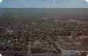
| Date: | 1955 |
|---|---|
| Description: | Aerial view of La Crosse, with Onalaska in the background. The highway is U.S. Highway 53 and the State Highway 35. |

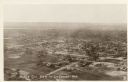
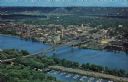
| Date: | 1953 |
|---|---|
| Description: | Aerial view of La Crosse and the Mississippi River. In the foreground is the new bridge as of 1953. |
| Date: | |
|---|---|
| Description: | Aerial view of La Crosse, with the Mississippi River in the distance. |

| Date: | 1950 |
|---|---|
| Description: | Aerial view of a farm and surrounding fields farmed with the contour method. Shocks of grain dot several of the fields. |
| Date: | |
|---|---|
| Description: | Letterhead of H.I. Bliss, a real estate agent, civil engineer, and county surveyor in La Crosse, Wisconsin. On the left a group of three men are surveying ... |

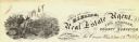
| Date: | 1900 |
|---|---|
| Description: | This set of photocopy bird's-eye-view maps include one view looking west from the top of Wisconsin River bluffs; and a second view looking east towards La ... |
| Date: | |
|---|---|
| Description: | Text on reverse reads: "Bird's-eye view of La Crosse, Wis., from Grandad Bluff. This thriving manufacturing, wholesale and retail city is an awe inspiring ... |
| Date: | |
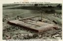
|---|---|
| Description: | Aerial view of The Trane Company, manufacturer of heating, cooling and air conditioning equipment. Caption reads: "Plant No. 2 — The Trane Company, L... |
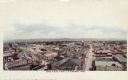
| Date: | |
|---|---|
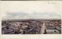
| Description: | Elevated view of central La Crosse. Caption reads: "Bird's Eye View, La Crosse, Wis." |
| Date: | |
|---|---|
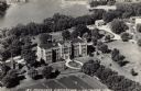
| Description: | Aerial view of an orphanage and grounds near the Mississippi River. Caption reads: "St. Michael's Orphanage — La Crosse, Wis." |
| Date: | |
|---|---|
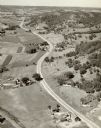
| Description: | Aerial view of a road, with several farms, fields and hills along it. Caption reads: "U.S. 16 near La Crosse, Wis." |
| Date: | 1951 |
|---|---|
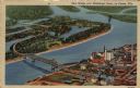
| Description: | Aerial view of a highway bridge crossing the Mississippi River and French Island. Caption reads: "New Bridge over Mississippi River, La Crosse, Wis." |
| Date: | |
|---|---|
| Description: | Photographic postcard of an aerial view over La Crosse and the I-90 Interstate bridge. French Island is in the foreground. |
| Date: | |
|---|---|
| Description: | Hand-colored bird's-eye view of La Crosse looking toward the river across the rooftops of commercial buildings and a few churches. Caption reads: "Bird's-E... |
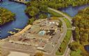
| Date: | |
|---|---|
| Description: | Aerial view of the Holiday Inn, between La Crosse on Barron Island in the beautiful Mississippi. A curved road is leading to a bridge across the Mississipp... |
If you didn't find the material you searched for, our Library Reference Staff can help.
Call our reference desk at 608-264-6535 or email us at:
