 Filter: Categories of Wisconsin Historical Images
Filter: Community of Kenosha
Filter: Subject of transportation
Filter: Categories of Wisconsin Historical Images
Filter: Community of Kenosha
Filter: Subject of transportation

| Date: | 1946 |
|---|---|
| Description: | International truck utilized by K*A*T Corporation for multi-automobile hauling. The driver is sitting behind the steering wheel looking out of the driver's... |

| Date: | 1946 |
|---|---|
| Description: | A man sits behind the steering wheel of an International truck utilized by K*A*T Corporation for multi-automobile hauling. |

| Date: | 1946 |
|---|---|
| Description: | Man driving International truck utilized by K*A*T Corporation for multi-automobile hauling. |
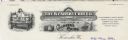
| Date: | |
|---|---|
| Description: | Letterhead of the Kenosha Crib Company of Kenosha, Wisconsin, "Manufacturers of the Latest in Children's Cribs". Features an outdoor scene of a child stand... |

| Date: | 1890 |
|---|---|
| Description: | View from the shore of Kenosha's North Pier and lighthouse. Waves are breaking on the shore of Lake Michigan. |

| Date: | 1871 |
|---|---|
| Description: | Engraved view of Kenosha harbor. A group of men fish from a pier in the foreground while several boats float through the harbor. A tug is pulling a large s... |

| Date: | 1861 |
|---|---|
| Description: | Depths shown by soundings. Shows township and sections, landownership and acreages, roads, railroads, and buildings. "Entered according to Act of Congress ... |

| Date: | 1910 |
|---|---|
| Description: | Map shows routes, post offices, churches, schools, houses, and roads on the rural delivery service route in blue lines. An explanation key appears on the l... |
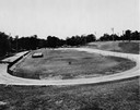
| Date: | 06 23 1936 |
|---|---|
| Description: | Velodrome at Washington Park with a "USA Work Program WPA" sign in the infield. Sprinklers are watering the grass. |
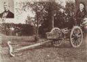
| Date: | 1838 |
|---|---|
| Description: | Ox-drawn cart in which Mr. and Mrs. Salmon Upson traveled from Connecticut in 1838. |

| Date: | 1855 |
|---|---|
| Description: | This map has relief shown by hachures and soundings and shows local streets, proposed roads, railroads, bridge wharfs, basin, north arm, and west arm of Ke... |

| Date: | 1948 |
|---|---|
| Description: | This map shows wards and precincts and includes a list of polling places by ward and precinct. The map reads: "Keep this Map . . . It Gives the Location of... |

| Date: | 1953 |
|---|---|
| Description: | This map is a blue line print and shows streets as well as some points of interest. |

| Date: | 1948 |
|---|---|
| Description: | This map shows a list of polling places by ward and precinct in the left margin, a list of assembly districts, and additional handwritten notes. Lake Michi... |

| Date: | 1961 |
|---|---|
| Description: | This is a photocopy of a map in blue line print that shows streets and places of interest. Inscribed in pen, at the bottom of the map, reads: "Sen. Zaborsk... |

| Date: | 1857 |
|---|---|
| Description: | This map was created from a survey made in December 1855 and shows local streets, proposed roads, railroads, the lake shore, bridge wharfs, the basin, the ... |

| Date: | 1910 |
|---|---|
| Description: | This map is a survey of Kenosha Harbor and shows local streets, public buildings, local businesses, and part of Lake Michigan. Included is text on sailing ... |

| Date: | 1857 |
|---|---|
| Description: | This map shows land ownership by name, local streets, wards, buildings, parks, a cemetery, and part of Lake Michigan. Depths are shown by soundings and nor... |

| Date: | |
|---|---|
| Description: | Aerial photograph of the Port of Kenosha and factories, with snow on the ground. There are four ships along the shoreline, and multiple factories on either... |

| Date: | 1945 |
|---|---|
| Description: | Port of Kenosha Transit Warehouse No. 1. There are two ships on the right side, one named "Broom Park." Three men are loading a car onto the ship using a c... |
If you didn't find the material you searched for, our Library Reference Staff can help.
Call our reference desk at 608-264-6535 or email us at: