 Filter: Categories of Wisconsin Historical Images
Filter: Community of Kenosha
Filter: Subject of architecture
Filter: Year of 1800-1899
Filter: Categories of Wisconsin Historical Images
Filter: Community of Kenosha
Filter: Subject of architecture
Filter: Year of 1800-1899
| Date: | 1860 |
|---|---|
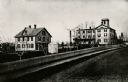
| Description: | Elevated view of the Durkee House built by Charles Durkee in 1843. |
| Date: | 1880 |
|---|---|
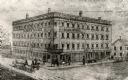
| Description: | The Kenosha water cure on the corner of N. Main and Grand Avenue. It was built in the 1840's for educational and religious purposes. It burned down in 1900... |

| Date: | 1870 |
|---|---|
| Description: | View across intersection towards Kimball's Hall, one of the first brick buildings in Kenosha. A sign on the right side of the building reads: "Dewey & Sinc... |
| Date: | 1872 |
|---|---|
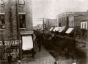
| Description: | Elevated view looking down Main Street. There are horse-drawn vehicles, and pedestrians are walking on the street and sidewalks. |
| Date: | 1860 |
|---|---|
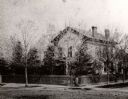
| Description: | The home of I.G. Merrill on the corner of Ann Street (now called Sheridan Road) and Prairie Avenue. A person is standing in front of the fence at the corne... |

| Date: | 1879 |
|---|---|
| Description: | The home of I.G. Merrill, located on the corner of Ann Street (now called Sheridan Road) and Prairie Avenue, in the winter. |

| Date: | 1880 |
|---|---|
| Description: | Stereograph of the exterior of St. Matthews Church. |

| Date: | 1891 |
|---|---|
| Description: | Elevated view of a barn raising on the farm of Alva Paddock in the township of Salem on Geneva Road, Highway 50. |

| Date: | 1890 |
|---|---|
| Description: | View from the shore of Kenosha's North Pier and lighthouse. Waves are breaking on the shore of Lake Michigan. |

| Date: | 1871 |
|---|---|
| Description: | Engraved view of Kenosha harbor. A group of men fish from a pier in the foreground while several boats float through the harbor. A tug is pulling a large s... |

| Date: | 1861 |
|---|---|
| Description: | Depths shown by soundings. Shows township and sections, landownership and acreages, roads, railroads, and buildings. "Entered according to Act of Congress ... |

| Date: | 1857 |
|---|---|
| Description: | This map shows land ownership by name, local streets, wards, buildings, parks, a cemetery, and part of Lake Michigan. Depths are shown by soundings and nor... |

| Date: | 07 19 1854 |
|---|---|
| Description: | This map shows the shore in 1844, 1850, and 1852, the length of and proposed additions to the pier. Relief is shown by hachures and depths are shown by sou... |
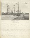
| Date: | 1856 |
|---|---|
| Description: | Lithograph image of several boats in a harbor. Most are flying American flags from their masts. One has a flag on which "C. Harrison" is printed. Someone h... |
If you didn't find the material you searched for, our Library Reference Staff can help.
Call our reference desk at 608-264-6535 or email us at:
