 Filter: Categories of Wisconsin Historical Images
Filter: Community of Kaukauna
Filter: Subject of transportation
Filter: Categories of Wisconsin Historical Images
Filter: Community of Kaukauna
Filter: Subject of transportation

| Date: | 12 21 1882 |
|---|---|
| Description: | Bird's-eye map of Kaukauna, from the Appleton Post Annual Review. |
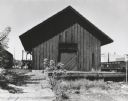
| Date: | 1961 |
|---|---|
| Description: | The Chicago and Northwestern railroad station. |

| Date: | 1955 |
|---|---|
| Description: | View across street towards the Kaukauna Public Library. |

| Date: | 1900 |
|---|---|
| Description: | Methodist Church next door to Epworth home in Kaukauna. |

| Date: | |
|---|---|
| Description: | View over a train stopped at a grain elevator in the foreground. The Hotel Ristau is across a street on the left, and a church building is in the distance ... |
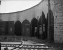
| Date: | 09 16 1961 |
|---|---|
| Description: | An interior view of an abandoned Chicago and North Western Railroad roundhouse. |

| Date: | 08 03 1962 |
|---|---|
| Description: | Elevated view of the Guard Lock on the Fox River Canal, looking east from the Highway 55 bridge. |
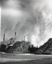
| Date: | |
|---|---|
| Description: | View across railroad tracks of billowing smokestacks at the Thilmany Paper Company plant. Stacks of logs are piled next to railroad tracks and cars. |
| Date: | 1940 |
|---|---|
| Description: | View from the second floor balcony of the Charles A Grignon House at Kaukauna showing the historic boat canal and the Fox River beyond it. |
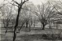
| Date: | 1940 |
|---|---|
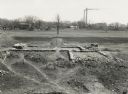
| Description: | Elevated view of foundation of the house built by Dominique DuCharme in 1790 and enlarged by Augustin Grignon after 1804. The Grignon family resided in the... |
| Date: | |
|---|---|
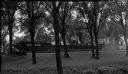
| Description: | View of the side of a barge owned by the Pluswood company on the Fox River Canal. The boat is seen through the trees on the lawn of the Charles A. Grignon ... |
| Date: | |
|---|---|
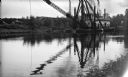
| Description: | View across water of the dredge "Winneconne" on the Fox River canal. Although undated the photograph was probably taken during the 1940s. The "Winneconne"... |

| Date: | 1960 |
|---|---|
| Description: | This map shows a plat of the city, wards, lots, local streets, roads, railroads, buildings, parks, and part of Fox River. The map includes tables for plat ... |

| Date: | 1890 |
|---|---|
| Description: | This map is a plat map and shows government buildings, churches, Klein’s Park, and the government dam in Kaukauna. The map includes text about Kaukauna wit... |

| Date: | 1891 |
|---|---|
| Description: | This blueprint manuscript map shows land owned by Green Bay & Mississippi Canal Co., Meade, Vilas, Patten, and Hewitt. Streets and the Fox River are labele... |

| Date: | 1891 |
|---|---|
| Description: | This blueprint manuscript map shows land owned by Kaukauna Water Power Co., Green Bay & Mississippi Canal Co., A.W. Patten, N.M. Edwards, and M.J. Meade. P... |
| Date: | |
|---|---|
| Description: | Elevated view of a row of businesses along the Fox River near the dam. There are horse-drawn vehicles in the street. Advertisements are on the side of the ... |

| Date: | |
|---|---|
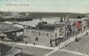
| Description: | View of the businesses lining Second Street. There is a horse and wagon at the curb, and boys are standing in the street. Caption reads: "Second Street, Ka... |

| Date: | |
|---|---|
| Description: | Elevated view of Kaukauna's south side, with the north side in the distance. There is a bridge over the Fox River. Caption reads: "Looking North from South... |
If you didn't find the material you searched for, our Library Reference Staff can help.
Call our reference desk at 608-264-6535 or email us at:
