 Filter: Categories of Wisconsin Historical Images
Filter: Community of Janesville
Filter: Year of 1800-1899
Filter: Year of 1870-1879
Filter: Categories of Wisconsin Historical Images
Filter: Community of Janesville
Filter: Year of 1800-1899
Filter: Year of 1870-1879

| Date: | 1877 |
|---|---|
| Description: | Bird's-eye map of Janesville on the Rock River. |
| Date: | 1870 |
|---|---|
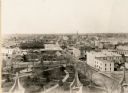
| Description: | Elevated view looking down Court Street in Janesville toward the west. |

| Date: | 1870 |
|---|---|
| Description: | Elevated view over river of Dodge Street in Janesville looking west. |
| Date: | 1876 |
|---|---|
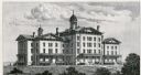
| Description: | The Institution for the Education of the Blind. |
| Date: | 1870 |
|---|---|
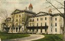
| Description: | The State Institute for the Blind, a school free for blind children of Wisconsin. Caption reads: "State Institute for Blind, Janesville, Wis." |
| Date: | 1870 |
|---|---|
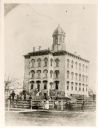
| Description: | Jefferson School, built on the site of the first cemetery in Janesville. |

| Date: | 1870 |
|---|---|
| Description: | Elevated view of the busy streets of Court and Milwaukee. Three prominent buildings in view are: Court Street Methodist Church on the far left (b. 1868), w... |

| Date: | 1870 |
|---|---|
| Description: | View from along right side of bridge of Milwaukee Street looking east in Janesville. The Myers House is located at the top of the hill. There is a sign for... |

| Date: | 1875 |
|---|---|
| Description: | Exterior of the second Rock County Court House which stood from 1896 to 1955. The Architect was E. Townsend Mix. |

| Date: | 1873 |
|---|---|
| Description: | This map shows landownership and acreages, lot and block numbers, roads and railroads, marshes, schools, churches, mills, rural buildings, and quarries. Re... |
If you didn't find the material you searched for, our Library Reference Staff can help.
Call our reference desk at 608-264-6535 or email us at:
