Filter: Categories of Wisconsin Historical Images
Filter: Community of Janesville
Filter: Year of 1800-1899
Filter: Subject of transportation
Filter: Categories of Wisconsin Historical Images
Filter: Community of Janesville
Filter: Year of 1800-1899
Filter: Subject of transportation

| Date: | 1877 |
|---|---|
| Description: | Bird's-eye map of Janesville on the Rock River. |

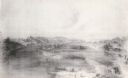
| Date: | 1860 |
|---|---|
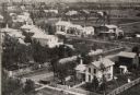
| Description: | Bird's-eye view of Janesville from the High School building. |
| Date: | 1870 |
|---|---|
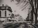
| Description: | Elevated view looking down Court Street in Janesville toward the west. |

| Date: | 1870 |
|---|---|
| Description: | Elevated view over river of Dodge Street in Janesville looking west. |
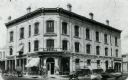
| Date: | 1887 |
|---|---|
| Description: | The Kimball and Lowell Hardware Store located on the corner of Franklin and Milwaukee Streets. |
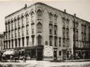
| Date: | 1892 |
|---|---|
| Description: | The Lappin block, Ed. Carpenter, proprietor. Businesses on this block include: Bort, Baily & Co., Dry Goods and Carpets; A.F. Hall & Co., "The Reliable Jew... |
| Date: | 1893 |
|---|---|
| Description: | View down Madison Street with houses along sidewalk. Caption reads: "View on Madison Street." |

| Date: | 1870 |
|---|---|
| Description: | Elevated view of the busy streets of Court and Milwaukee. Three prominent buildings in view are: Court Street Methodist Church on the far left (b. 1868), w... |
| Date: | 1893 |
|---|---|
| Description: | Looking northwest from the Methodist Episcopal Church, Main Street, with trolley track running down the center of the street. |

| Date: | 1865 |
|---|---|
| Description: | Milwaukee Street looking west. In the foreground is a dog standing on a bridge. Signs on a building on the right read: "Furniture" and "Valley Chief Reaper... |

| Date: | 1870 |
|---|---|
| Description: | View from along right side of bridge of Milwaukee Street looking east in Janesville. The Myers House is located at the top of the hill. There is a sign for... |
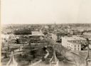
| Date: | 1893 |
|---|---|
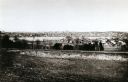
| Description: | View from the south, with a railroad in the foreground, a river in the middle distance, and Janesville in the background. |
| Date: | 1865 |
|---|---|
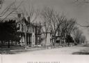
| Description: | Aerial view of a residential part of Janesville. |

| Date: | 1865 |
|---|---|
| Description: | Elevated view of Milwaukee Street. |
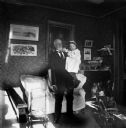
| Date: | 1898 |
|---|---|
| Description: | An elderly man stands in a room holding a small girl. Caption on negative reads, "Mary C. and Grandpa." |
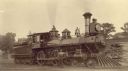
| Date: | 1886 |
|---|---|
| Description: | Right side view of Chicago, Milwaukee & St. Paul Railway locomotive engine no. 632. |

| Date: | 1853 |
|---|---|
| Description: | Map covers area between the cities of Janesville and Kenosha in Rock, Walworth, and Kenosha counties for railroad routes. Lakes and counties are labelled. ... |

| Date: | 1860 |
|---|---|
| Description: | Map showing a plat of the city, land ownership by name, wards by number, local streets, buildings, fair grounds, nurseries, and part of Rock River. The map... |
If you didn't find the material you searched for, our Library Reference Staff can help.
Call our reference desk at 608-264-6535 or email us at: