 Filter: Categories of Wisconsin Historical Images
Filter: Community of Janesville
Filter: Subject of transportation
Filter: Subject of streets
Filter: Categories of Wisconsin Historical Images
Filter: Community of Janesville
Filter: Subject of transportation
Filter: Subject of streets
| Date: | 1905 |
|---|---|
| Description: | Exterior view of the Janesville Public Library on South Main Street. |
| Date: | 1905 |
|---|---|
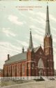
| Description: | Exterior view of St. Mary's Catholic Church. Caption reads: "St. Mary's Catholic Church, Janesville, Wis." |
| Date: | 1951 |
|---|---|
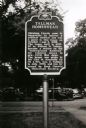
| Description: | Tallman Homestead Marker. There are automobiles parked along the curb in the background. |
| Date: | 1865 |
|---|---|
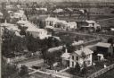
| Description: | Aerial view of a residential part of Janesville. |

| Date: | 1900 |
|---|---|
| Description: | View across street towards the Y.M.C.A. building. Caption reads: "Janesville, Wis. Y.M.C.A." |

| Date: | |
|---|---|
| Description: | View across street towards the Y.M.C.A building. Caption reads: "Y. M. C. A. Building, Janesville, Wis." |

| Date: | 1865 |
|---|---|
| Description: | Elevated view of Milwaukee Street. |

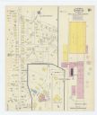
| Date: | 1860 |
|---|---|
| Description: | Map showing a plat of the city, land ownership by name, wards by number, local streets, buildings, fair grounds, nurseries, and part of Rock River. The map... |
| Date: | 1927 |
|---|---|
| Description: | This map shows a plat of city, a numbering system, local streets, railroads, and part of the Rock River. The map is indexed by street name and reads: "Copy... |

| Date: | 1900 |
|---|---|
| Description: | This map includes an index of streets and schools, and shows parks and public lands, as well as industrial sites. |

| Date: | 1973 |
|---|---|
| Description: | This map includes an index of streets and schools and also shows parks, schools and public lands, and industrial sites. Portions of the map are in green an... |
| Date: | |
|---|---|
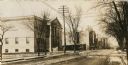
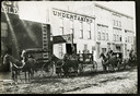
| Description: | View from across unpaved street of four men with horse-drawn hearses lined up in front of an undertaking building. The other storefronts are a stable on th... |
| Date: | 1924 |
|---|---|
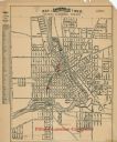
| Description: | This map of Janesville was distrusted by the Fifield Lumber Company and features labeled streets, the Rock River, and Fifield Lumber Company buildings in r... |
| Date: | |
|---|---|
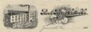
| Description: | Memohead of the Rock River Cotton Company, with an elevated three-quarter view of the company building on the left, and a branch of the cotton plant with b... |

| Date: | 10 1969 |
|---|---|
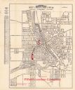
| Description: | A street map of Janesville showing the block numbers on each street. Other landmarks are labeled such as chain stores, parks, schools, manufacturing compa... |

| Date: | 1911 |
|---|---|
| Description: | This map shows streets, railroads, the city house numbering system, and the Rock River. The left margin includes a street index. |
| Date: | 1915 |
|---|---|
| Description: | A Sanborn map of a portion of Janesville, including the Rock River Sugar Company. |
| Date: | 1908 |
|---|---|
| Description: | View across intersection towards the Government Building with arched entrances and turrets. Caption reads: "U.S. Government Building and Post Office." |

| Date: | |
|---|---|
| Description: | View across street towards the Parker Pen Factory, with a large, electric sign on the roof. Caption reads: "Parker Pen Company, Janesville, Wis." |

| Date: | |
|---|---|
| Description: | View of the neo-classical post office building. There is a flag on a flagpole on the roof. Caption reads: "Post Office, Janesville, Wis." |
If you didn't find the material you searched for, our Library Reference Staff can help.
Call our reference desk at 608-264-6535 or email us at: