 Filter: Categories of Wisconsin Historical Images
Filter: Community of Greendale
Filter: Subject of transportation
Filter: Categories of Wisconsin Historical Images
Filter: Community of Greendale
Filter: Subject of transportation

| Date: | 08 15 1942 |
|---|---|
| Description: | A young girl dances near a man wearing a tie on the announcer's platform at a Civilian Defense Rally. To the far left a microphone is visible, and in the b... |
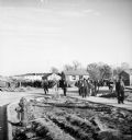
| Date: | 1937 |
|---|---|
| Description: | Large group of construction workers walking through neighborhood of houses that are in the middle of being constructed. |
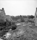
| Date: | 1937 |
|---|---|
| Description: | Men work to level the ground for foundations to be poured for homes. Exposed brick walls of partially constructed homes are on the left and right, and a di... |
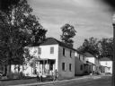
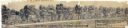
| Date: | 1936 |
|---|---|
| Description: | View from lawn of curved residential street lined with recently constructed housing and lampposts. A car sits in a driveway of a house on the left, and fur... |

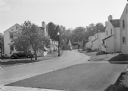
| Date: | 1936 |
|---|---|
| Description: | View up residential street with newly constructed houses, young trees and lampposts. Men in suits and hats walk along the sidewalk. A speed limit sign is o... |
| Date: | 09 1939 |
|---|---|
| Description: | View from road of a group of seven children playing in front of a house and on the porch, while a woman holding a bag of groceries walks past on the sidewa... |
| Date: | 03 03 1937 |
|---|---|
| Description: | A pencil drawing of a proposed area of the planned community of Greendale, Wisconsin. The community was established as an objective of the Department of Ag... |

| Date: | 1960 |
|---|---|
| Description: | This map of Greedale shows local streets, parks, schools, and churches and includes manuscript annotations in green and blue showing tracts and parcels of ... |

| Date: | 1938 |
|---|---|
| Description: | This map shows buildings, lots, parks, schools, pumping stations, sites reserved for churches, and water towers. |

| Date: | 1964 |
|---|---|
| Description: | This map shows various zoning sections and includes labeled streets, parks, and cemeteries. The upper left corner contains a legend of land use. |
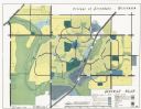
| Date: | 1962 |
|---|---|
| Description: | This map shows zoning, community facilities, roads, rivers and thoroughfares. The lower right corner includes a key titled "General Plan". |

| Date: | 1940 |
|---|---|
| Description: | View of man carrying a metal trash bin towards a dump truck. A man sits in the driver's seat. Another man stands near metal trash bins behind a fence along... |
If you didn't find the material you searched for, our Library Reference Staff can help.
Call our reference desk at 608-264-6535 or email us at: