 Filter: Categories of Wisconsin Historical Images
Filter: Community of Fort Atkinson
Filter: Year of 1800-1899
Filter: Categories of Wisconsin Historical Images
Filter: Community of Fort Atkinson
Filter: Year of 1800-1899

| Date: | 1870 |
|---|---|
| Description: | Birds eye drawing of Fort Atkinson, Jefferson County, depicts street names and street layouts, houses, trees, Rock River and Bark River. A reference key at... |

| Date: | 1893 |
|---|---|
| Description: | This photocopy of a bird’s-eye-view map shows illustrated houses and various buildings. Streets and the Rock River are labeled. An index to points of inter... |
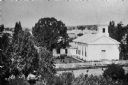
| Date: | 1850 |
|---|---|
| Description: | Elevated view from hill of the First Methodist Church. |
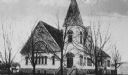
| Date: | 1880 |
|---|---|
| Description: | View of the First Methodist Church. |
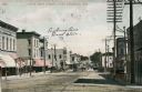
| Date: | 1895 |
|---|---|
| Description: | View of lower Main Street lined with electric power lines and storefronts. Caption reads: "Lower Main Street, Fort Atkinson, Wis." |
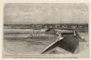
| Date: | 1876 |
|---|---|
| Description: | Elevated view of Fort Howard taken from Elmore and Kelly's Elevator with the dam and river. A tugboat is in the river above the dam. Caption reads: "View o... |

| Date: | 09 1884 |
|---|---|
| Description: | Sanborn map of Fort Atkinson including Barrie, Germany, and North Water Streets. |

| Date: | 09 1884 |
|---|---|
| Description: | Sanborn map of Fort Atkinson including South Water and Milwaukee Streets. |

| Date: | 1870 |
|---|---|
| Description: | Bird’s-eye view map. "Looking north east." Indexed for points of interest. Shows homes, businesses, and the Bark and Rock River. Streets running west to ea... |
If you didn't find the material you searched for, our Library Reference Staff can help.
Call our reference desk at 608-264-6535 or email us at: