 Filter: Categories of Wisconsin Historical Images
Filter: Community of Fort Atkinson
Filter: Subject of transportation
Filter: Categories of Wisconsin Historical Images
Filter: Community of Fort Atkinson
Filter: Subject of transportation

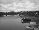
| Date: | 07 21 1962 |
|---|---|
| Description: | A parking lot underneath a newly developed block of stores. The Rock River is visible just beyond the parking lot. There is a bridge in the background. |
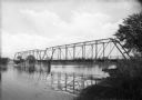
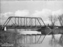
| Date: | |
|---|---|
| Description: | View from shoreline toward an unidentified railroad bridge spanning a river. |

| Date: | |
|---|---|
| Description: | View over tree-tops toward a man rowing a boat beneath a partially covered bridge spanning the Rock River. Factories, industrial buildings, and Saint Paul'... |
| Date: | |
|---|---|
| Description: | Elevated view looking west from the Main Street Bridge, a partially covered wooden bridge spanning the Rock River. In the foreground on the right are boats... |

| Date: | |
|---|---|
| Description: | View down Milwaukee Avenue. On the left side of the road, the Daughters of the American Revolution Monument, erected in 1907, can be seen among trees trea... |
| Date: | |
|---|---|
| Description: | View from the left side riverbank of the Bark River, whose water is reflecting the bridge above. A man is driving an automobile over the bridge toward the ... |
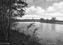
| Date: | |
|---|---|
| Description: | View from hill on left side riverbank of the Rock River. In the distance is a bridge, water tower, and Saint Paul's Lutheran Church. |
| Date: | 1910 |
|---|---|
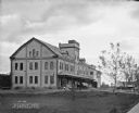
| Description: | Exterior of Jones' Sausage Factory. Two men are leaning out the window above the side of the porch roof. Bicycles are leaning against the side of the brick... |

| Date: | |
|---|---|
| Description: | Exterior view across road toward the Methodist Church. Children play with a wagon on the sidewalk in front of the church. Two sets of stairs lead to a side... |

| Date: | |
|---|---|
| Description: | View down South Main Street. Houses are on the left, and trees line the street. |
| Date: | |
|---|---|
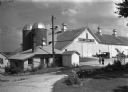
| Description: | A model dairy farm maintained by Hoard's "Dairyman Magazine" for experimental purposes. Two women are walking in the driveway near the buildings on the rig... |

| Date: | |
|---|---|
| Description: | View of a wooden bridge spanning the Bark River. Probably late fall or early spring as the trees are leafless. Caption reads: "Bark River Bridge, Fort Atki... |

| Date: | 09 1884 |
|---|---|
| Description: | Sanborn map of Fort Atkinson including Barrie, Germany, and North Water Streets. |

| Date: | 09 1884 |
|---|---|
| Description: | Sanborn map of Fort Atkinson including South Water and Milwaukee Streets. |

| Date: | 1870 |
|---|---|
| Description: | Bird’s-eye view map. "Looking north east." Indexed for points of interest. Shows homes, businesses, and the Bark and Rock River. Streets running west to ea... |

| Date: | 1920 |
|---|---|
| Description: | Shows ward boundaries, corporation limits, plat of town, land ownership by name, local streets, parks, railroads, and parts of Rock River. Wards appear in ... |

| Date: | 1947 |
|---|---|
| Description: | Lower left hand corner features a legend. "Drawn 1938, revised 1947." Shows water mains, hydrants, corporation limits, city ward divisions, fire proof buil... |

| Date: | 1976 |
|---|---|
| Description: | Includes index of streets and of local businesses. Shows location of Citizens State Bank, roads, highways, railroads, parks, cemeteries, and city sanitary ... |

| Date: | 1910 |
|---|---|
| Description: | Elevated view over the ox-bow of the Bark River in early morning. Buildings, dwellings and barns are in the foreground at the bottom of the hill, and a bri... |

| Date: | 06 2008 |
|---|---|
| Description: | View looking east of a 1000-year-old Indian intaglio effigy in the shape of a panther. The effigy, which is on the north bank of the Rock River, is filled ... |
If you didn't find the material you searched for, our Library Reference Staff can help.
Call our reference desk at 608-264-6535 or email us at: