 Filter: Categories of Wisconsin Historical Images
Filter: Community of Fond du Lac
Filter: Subject of water
Filter: Categories of Wisconsin Historical Images
Filter: Community of Fond du Lac
Filter: Subject of water

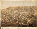
| Date: | 1867 |
|---|---|
| Description: | Birds eye drawing of Fond du Lac depicts street names and street layouts, houses, buildings, trees, and the Fond du Lac River. A reference key at the botto... |
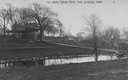
| Date: | 1920 |
|---|---|
| Description: | View across pond looking towards the Buena Vista house on Lake de Neveu. Caption reads: "The House Buena Vista The de Neveu Farm". |

| Date: | 1920 |
|---|---|
| Description: | View looking down hill towards the Buena Vista house on Lake de Neveu. Caption reads: "The House Buena Vista The de Neveu Farm". |

| Date: | 1920 |
|---|---|
| Description: | Site where the first French trading post in Wisconsin was built at the fork of the Fond du Lac River in 1787. The site is located near the city's gas plant... |
| Date: | |
|---|---|
| Description: | View across water towards the shoreline on the right, with a lighthouse in the distance. |
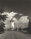
| Date: | 1954 |
|---|---|
| Description: | View down road towards the Fond du Lac lighthouse, built in 1933. There are cumulus clouds in the sky, and pine trees are lining the shore. |

| Date: | 1857 |
|---|---|
| Description: | Quarter section of a map of the city of Fond du Lac featuring an illustration of the Lewis House. |

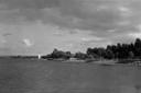
| Date: | 1934 |
|---|---|
| Description: | Tourist camp at Lakeside Park on Lake Winnebago. |

| Date: | |
|---|---|
| Description: | Lithograph view towards river of the American Fur Companies buildings and fenced enclosures, surrounded by hills and trees. |
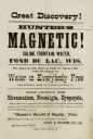
| Date: | |
|---|---|
| Description: | Advertisement for Hunter's Magnetic Saline Fountain Water which was being given away as promotion by an agent in Fond du Lac. The water supposedly cured rh... |
| Date: | |
|---|---|
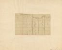
| Description: | Map shows rivers and acreages in part of Fond du Lac township and Fond du Lac, Wisconsin. |

| Date: | 1932 |
|---|---|
| Description: | Children and adults enjoy a sunny day at the Lake Winnebago shore in Lakeside Park in Fond du Lac. |

| Date: | 1840 |
|---|---|
| Description: | Shows plat of town, local streets, Fond du Lac River, and part of Lake Winnebago. |
| Date: | 1867 |
|---|---|
| Description: | Bird’s-eye view map. Indexed for points of interest. |

| Date: | 1874 |
|---|---|
| Description: | Includes index to key buildings. Shows local streets, railroads, fairgrounds, mills, schools, churches, and part of Lake Winnebago. Streets running west to... |

| Date: | 1916 |
|---|---|
| Description: | Includes index to businesses, churches, and schools. Shows local streets, buildings, railroads, ward divisions, Fond du Lac River, and part of Lake Winneba... |

| Date: | 1956 |
|---|---|
| Description: | Includes street index. Shows local streets, parks, highways, railroads, Fond du Lac River, and part of lake Winnebago. Also includes text on points of inte... |

| Date: | 1956 |
|---|---|
| Description: | Includes street index and index to points of interest. Shows land ownership by name, plat of town, local streets, schools, parks, highways, railroads, ward... |

| Date: | 1800 |
|---|---|
| Description: | Shows plat of town, land ownership by name, local streets, courthouses, churches, hotels, mills, railroads, railroad stations, lakes, and rivers. Includes ... |

| Date: | 1800 |
|---|---|
| Description: | Ink and watercolor on tracing paper. Shows plat of town, local streets, Fond du Lac River, and part of Lake Winnebago. |
If you didn't find the material you searched for, our Library Reference Staff can help.
Call our reference desk at 608-264-6535 or email us at: