 Filter: Categories of Wisconsin Historical Images
Filter: Community of Fond du Lac
Filter: Subject of architecture
Filter: Year of 1800-1899
Filter: Categories of Wisconsin Historical Images
Filter: Community of Fond du Lac
Filter: Subject of architecture
Filter: Year of 1800-1899

| Date: | 1867 |
|---|---|
| Description: | Birds eye drawing of Fond du Lac depicts street names and street layouts, houses, buildings, trees, and the Fond du Lac River. A reference key at the botto... |
| Date: | 1890 |
|---|---|
| Description: | Stereograph view of a large crowd of people on a construction site. There is a horse and carriage with the Fond du Lac Machine & Iron Works in the backgrou... |

| Date: | 1857 |
|---|---|
| Description: | A quarter section of a map of the city of Fond du Lac. This section features an illustration of Amory Hall and the Exchange Bank of Darling & Co. |
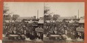
| Date: | 1890 |
|---|---|
| Description: | Exterior view from across road of men gathered outside a store and saloon. Most of the men hold a glass of beer as though toasting. Two teams of horses are... |

| Date: | 1862 |
|---|---|
| Description: | This map shows townships and sections, landownership and acreages, roads, railroads, cemeteries, churches, schools, mills, and stone quarries. "Engraved, p... |

| Date: | 1874 |
|---|---|
| Description: | Includes index to key buildings. Shows local streets, railroads, fairgrounds, mills, schools, churches, and part of Lake Winnebago. Streets running west to... |

| Date: | 1800 |
|---|---|
| Description: | Shows plat of town, land ownership by name, local streets, courthouses, churches, hotels, mills, railroads, railroad stations, lakes, and rivers. Includes ... |
If you didn't find the material you searched for, our Library Reference Staff can help.
Call our reference desk at 608-264-6535 or email us at: