 Filter: Categories of Wisconsin Historical Images
Filter: Community of Eau Claire
Filter: Year of 1800-1899
Filter: Year of 1870-1879
Filter: Categories of Wisconsin Historical Images
Filter: Community of Eau Claire
Filter: Year of 1800-1899
Filter: Year of 1870-1879

| Date: | 1872 |
|---|---|
| Description: | Birds-eye drawing of Eau Claire depicts street names and street locations, houses, trees, bridges, piers, canals, railroads, and the Chippewa and Eau Clair... |
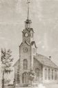
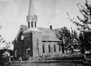
| Date: | 1870 |
|---|---|
| Description: | View of a Baptist church, two small trees, and a man standing in front of the church, wearing a top hat. Baptist Church, 4th Avenue and Niagara Street, bui... |
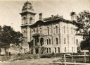
| Date: | 1875 |
|---|---|
| Description: | View of the courthouse. Roof and lower part have since been changed. |

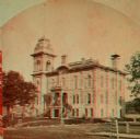
| Date: | 1875 |
|---|---|
| Description: | Stereograph of the courthouse before remodeling during the spring or summer. |

| Date: | 1875 |
|---|---|
| Description: | View of the courthouse, with bell tower. The building was built about 1870. The roof and lower part have since been changed. |
| Date: | 1875 |
|---|---|
| Description: | Original part built in 1856, where the present Eau Claire House stands. It was later moved to another site and eventually torn down to make room for the Y.... |
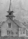
| Date: | 1870 |
|---|---|
| Description: | Methodist church on Barstow Street, built during the 1860's. |
| Date: | 1875 |
|---|---|
| Description: | Methodist Episcopal church, located on Lake Street. |
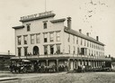
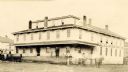
| Date: | 1875 |
|---|---|
| Description: | Front view of the inn. Several men and women are either standing or sitting on the balcony, and several people are standing on the porch under the balcony.... |

| Date: | 1870 |
|---|---|
| Description: | Third Ward, East Side, or "Bartlett School." This is probably the earliest picture in existence and is copied form the margin of "an old map." This first... |
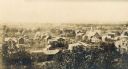
| Date: | 1870 |
|---|---|
| Description: | Elevated view of the many buildings in Eau Claire's lower east side. |

| Date: | 1870 |
|---|---|
| Description: | Elevated view of the town, looking northwest. The Chippewa River is in the foreground, with a lot of buildings, an intersection, and distant hills. One bui... |
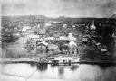
| Date: | 1870 |
|---|---|
| Description: | View of the town and Chippewa river, with a steamboat in the center along the riverbank. A smaller boat is next to the steamboat, with a man standing eithe... |

| Date: | 1875 |
|---|---|
| Description: | Water street, before the fire of the 1880's, from the corner of Fifth avenue, looking east with storefronts and fire engine house. |
| Date: | 1875 |
|---|---|
| Description: | Stereograph of the courthouse before remodeling during the spring or summer. |

| Date: | 1875 |
|---|---|
| Description: | Shows land ownership by name, local streets, buildings, cemeteries, Chippewa River, and Half Moon Lake. Includes 1 inset map of Eau Claire. Also includes c... |

| Date: | 1877 |
|---|---|
| Description: | Relief shown by hachures. Shows land ownership by name, wards, railroads, mills, dams, city limits, Chippewa River, and Half Moon Lake. Includes index of m... |

| Date: | 1877 |
|---|---|
| Description: | Relief shown by hachures. Shows land ownership by name, wards, railroads, mills, dams, city limits, Chippewa River, and Half Moon Lake. Includes index of m... |
If you didn't find the material you searched for, our Library Reference Staff can help.
Call our reference desk at 608-264-6535 or email us at:
