 Filter: Categories of Wisconsin Historical Images
Filter: Community of Eau Claire
Filter: Year of 1800-1899
Filter: Type of Map or Atlas
Filter: Categories of Wisconsin Historical Images
Filter: Community of Eau Claire
Filter: Year of 1800-1899
Filter: Type of Map or Atlas

| Date: | 1872 |
|---|---|
| Description: | Birds-eye drawing of Eau Claire depicts street names and street locations, houses, trees, bridges, piers, canals, railroads, and the Chippewa and Eau Clair... |

| Date: | 1891 |
|---|---|
| Description: | Bird's-eye view of Eau Claire. |

| Date: | 1875 |
|---|---|
| Description: | Shows land ownership by name, local streets, buildings, cemeteries, Chippewa River, and Half Moon Lake. Includes 1 inset map of Eau Claire. Also includes c... |

| Date: | 1877 |
|---|---|
| Description: | Relief shown by hachures. Shows land ownership by name, wards, railroads, mills, dams, city limits, Chippewa River, and Half Moon Lake. Includes index of m... |

| Date: | 1877 |
|---|---|
| Description: | Relief shown by hachures. Shows land ownership by name, wards, railroads, mills, dams, city limits, Chippewa River, and Half Moon Lake. Includes index of m... |

| Date: | 1889 |
|---|---|
| Description: | Shows city limits, railroads, mills, schools, cemeteries, dams, parks, lumber yards, log canals, log reservoir, Chippewa River, Eau Claire River, and Half ... |
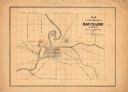
| Date: | 1860 |
|---|---|
| Description: | This map has relief shown by hachures and shows roads, railroads, proposed railroads, creeks, Half Moon Lake, Mount Adin, Mount Tom, Mount Sumeon, and part... |
If you didn't find the material you searched for, our Library Reference Staff can help.
Call our reference desk at 608-264-6535 or email us at:
