 Filter: Categories of Wisconsin Historical Images
Filter: Community of Eau Claire
Filter: Subject of transportation
Filter: Categories of Wisconsin Historical Images
Filter: Community of Eau Claire
Filter: Subject of transportation

| Date: | |
|---|---|
| Description: | Letterhead of the Eau Claire Transportation Company, "urban passenger carriers," with a three-quarter view of a red and yellow city bus marked "Olson Stree... |
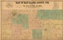
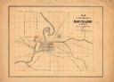
| Date: | 1902 |
|---|---|
| Description: | This 1902 map of Eau Claire County, Wisconsin, shows the township and range grid, towns, sections, landownership and acreages, roads and railroads, and sel... |
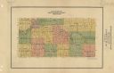
| Date: | 1926 |
|---|---|
| Description: | Map of Eau Claire County, Wisconsin Shows highways, railroads, hydrography, and townships. |
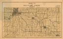
| Date: | 1911 |
|---|---|
| Description: | Map shows townships and sections, roads, and railroads. "W.W. Downs, attorney-at-law, Eau Claire, Wis." |
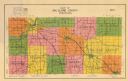
| Date: | 1933 |
|---|---|
| Description: | Map shows roads, township and range, water, and cultural features. |

| Date: | 1875 |
|---|---|
| Description: | Shows land ownership by name, local streets, buildings, cemeteries, Chippewa River, and Half Moon Lake. Includes 1 inset map of Eau Claire. Also includes c... |

| Date: | 1877 |
|---|---|
| Description: | Relief shown by hachures. Shows land ownership by name, wards, railroads, mills, dams, city limits, Chippewa River, and Half Moon Lake. Includes index of m... |

| Date: | 1877 |
|---|---|
| Description: | Relief shown by hachures. Shows land ownership by name, wards, railroads, mills, dams, city limits, Chippewa River, and Half Moon Lake. Includes index of m... |

| Date: | 1889 |
|---|---|
| Description: | Shows city limits, railroads, mills, schools, cemeteries, dams, parks, lumber yards, log canals, log reservoir, Chippewa River, Eau Claire River, and Half ... |

| Date: | 1964 |
|---|---|
| Description: | Shows local streets, bus routes, highways, airport, Dells Pond, Half Moon Lake, Chippewa River, and Eau Claire River. Includes 2 inset maps: Location map a... |
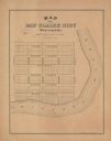
| Date: | 1900 |
|---|---|
| Description: | Shows plat of town, local streets, town sections, and Chippewa River. Streets running horizontally begin at the top with "Lake Street" and end with "Water ... |

| Date: | 1926 |
|---|---|
| Description: | Relief shown by hachures. Shows local streets, roads, railroads, businesses, Half Moon Lake, Chippewa River, and log reservoir. |
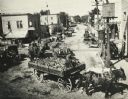
| Date: | 1920 |
|---|---|
| Description: | Elevated view of farmers bringing corn to the Lange Canning Co. plant. View looking west, from the west end of the old Madison Street bridge. |

| Date: | 1918 |
|---|---|
| Description: | This map has relief shown by hachures and is indexed by street name and buildings. The map shows plat of town, city limits, local streets, railroads, schoo... |
| Date: | 1860 |
|---|---|
| Description: | This map has relief shown by hachures and shows roads, railroads, proposed railroads, creeks, Half Moon Lake, Mount Adin, Mount Tom, Mount Sumeon, and part... |
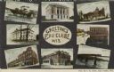
| Date: | 1910 |
|---|---|
| Description: | Color enhanced postcard with eight views of buildings, bridges, and dams. In the center is written: "Greetings from Eau Claire Wis." |
| Date: | 1910 |
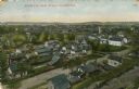
|---|---|
| Description: | Color enhanced bird's-eye view of Eau Claire. Caption reads: "Birds-Eye View of Eau Claire, Wis." |
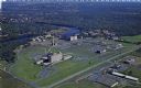
| Date: | 1950 |
|---|---|
| Description: | Aerial view of Sacred Heart Hospital. |
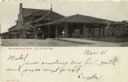
| Date: | 1900 |
|---|---|
| Description: | Black and white photographic postcard view of the Northwestern depot, with horse-drawn carriages and bicycles. Caption reads: "Northwestern Depot, Eau Clai... |
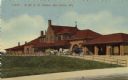
| Date: | 1910 |
|---|---|
| Description: | Color illustration of the Northwestern railroad station. A horse-drawn carriage is in front of the station. Caption reads: "N. W. R. R. Station, Eau Claire... |
If you didn't find the material you searched for, our Library Reference Staff can help.
Call our reference desk at 608-264-6535 or email us at: