 Filter: Categories of Wisconsin Historical Images
Filter: Community of De Pere
Filter: Year of 1800-1899
Filter: Categories of Wisconsin Historical Images
Filter: Community of De Pere
Filter: Year of 1800-1899
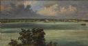
| Date: | 1856 |
|---|---|
| Description: | ". . . At De Pere they stopped on the west shore for a broad sketch of the dwellings clustered on both sides of the river. The distant dam, the mills, ware... |

| Date: | 1893 |
|---|---|
| Description: | Bird’s-eye view of Depere looking North. Includes illustrations and an index to points of interest. |

| Date: | 1830 |
|---|---|
| Description: | Plat map showing lots and streets. A few lots are marked with names, including: Boyd, Newton, Williams, Baird, Suydam, etc. |

| Date: | 1875 |
|---|---|
| Description: | Elevated view over De Pere. In the foreground is the De Pere News Office and Post Office building. Behind it people are walking on the bridge over the Fox ... |
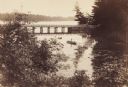
| Date: | 1889 |
|---|---|
| Description: | View from shoreline looking down on Mud Creek, about two miles above De Pere, showing small bridge and a man in a rowboat. |

| Date: | 1870 |
|---|---|
| Description: | Section of overall panorama, showing railroad station. |

| Date: | 1875 |
|---|---|
| Description: | View over town looking east from the railroad station. |
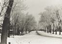
| Date: | 1889 |
|---|---|
| Description: | Winter scene of North Broadway at Cass Street, De Pere, Wisconsin. Streets are snow covered. |

| Date: | 1899 |
|---|---|
| Description: | Residential street, North Broadway at Cass Street. |

| Date: | 1800 |
|---|---|
| Description: | This map shows plat of the town, local streets, plank roads, and part of the Fox River. The bottom of the map includes annotations, probably in pencil. |

| Date: | 1875 |
|---|---|
| Description: | Handwritten note on back identifies this elevated view as the west side of Broadway from National Bank, looking south. The Fox River is in the background o... |

| Date: | 1888 |
|---|---|
| Description: | This is a reproduction of a map originally published in 1829 by R.W. Chandler, a pioneer settler of Galena. It is based on an earlier map by surveyor Luciu... |

| Date: | 1850 |
|---|---|
| Description: | This photocopied map shows lot and block numbers, selected buildings, street names and state lock located on the Fox River. Includes a description of Deper... |
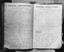
| Date: | 08 1871 |
|---|---|
| Description: | Caption reads: "Photocopy of the hotel register at the De Pere House De Pere Wis from Friday August 4 to Tuesday August 8 1871. Among names to be noted are... |

| Date: | 1870 |
|---|---|
| Description: | Elevated view of an unpaved main street, with the Village House across the street in the center background. Wooden buildings and wooden sidewalks are on bo... |

| Date: | 1875 |
|---|---|
| Description: | Elevated view of several buildings, with bridge and railroad tracks, and the Fox River. In the foreground on the right is the Commercial House, with three ... |
| Date: | 1885 |
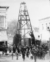
|---|---|
| Description: | Elevated view of a crowd of people standing near an artesian well. Men wearing long coats and hats to protect them from the water are standing on and unde... |
If you didn't find the material you searched for, our Library Reference Staff can help.
Call our reference desk at 608-264-6535 or email us at: