 Filter: Categories of Wisconsin Historical Images
Filter: Community of Columbus
Filter: Year of 1800-1899
Filter: Categories of Wisconsin Historical Images
Filter: Community of Columbus
Filter: Year of 1800-1899

| Date: | 1868 |
|---|---|
| Description: | This 1868 birds-eye view depicts the buildings, streets, railroad, vegetation and topography of Columbus, Wisconsin. The high school, cemetery, railroad de... |
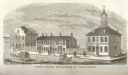
| Date: | 1815 |
|---|---|
| Description: | Engraved view of the first state buildings in Columbus, Ohio, including the United States Courthouse, Public Offices and the Old State House. A number of p... |

| Date: | 1856 |
|---|---|
| Description: | This map shows plat of town, local streets, railroads, projected railroads, residential buildings, mills, and part of the Crawfish River. The map includes ... |

| Date: | 1856 |
|---|---|
| Description: | This map is ink and pencil on paper and shows plat of the town, local streets, and blocks and lots by number. The map includes explanatory text. |
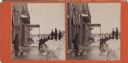
| Date: | 03 03 1881 |
|---|---|
| Description: | Stereograph of men standing on a cleared sidewalk in front of storefronts. Three men are standing on snowbanks along the curb. Several men are holding snow... |
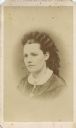
| Date: | 1870 |
|---|---|
| Description: | Vignetted quarter-length head and shoulders portrait of a woman. |
If you didn't find the material you searched for, our Library Reference Staff can help.
Call our reference desk at 608-264-6535 or email us at:

