Filter: Categories of Wisconsin Historical Images
Filter: Community of Burlington
Filter: Subject of water
Filter: Categories of Wisconsin Historical Images
Filter: Community of Burlington
Filter: Subject of water
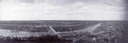
| Date: | 1910 |
|---|---|
| Description: | Aerial view of town, with a river and the horizon in the distance. |

| Date: | 1950 |
|---|---|
| Description: | View of stones in a quarry used by the Mormons in the settlement formerly known as Voree. |
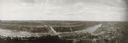
| Date: | 1910 |
|---|---|
| Description: | Panoramic photographic view of Burlington, taken with a local Al-vista panoramic camera. |
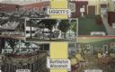
| Date: | |
|---|---|
| Description: | Color postcard of five views of Liggett's Resort on Brown's Lake. Front view, "Marine Dining Room," "Marine Bar," "Guest Room" and "Marine Lounge." |

| Date: | |
|---|---|
| Description: | Black and white postcard of a river view of the Fox River as it runs through the city of Burlington. In the foreground is a railroad bridge. Just behind th... |

| Date: | 05 25 1905 |
|---|---|
| Description: | Black and white postcard of a view of the Fox River as it flows through Burlington. The shoreline is wooded. Red text below reads: "View of Fox River, Burl... |

| Date: | 09 02 1908 |
|---|---|
| Description: | Black and white postcard of the Mill Dam. The water is running over the dam from the left and becoming rapids on the right. There is a wooded shoreline on ... |

| Date: | |
|---|---|
| Description: | Color postcard of an aerial view of Cerami's Island View Hotel Motel Resort on the shore of Brown's Lake. |
| Date: | |
|---|---|
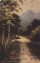
| Description: | Color reproduction of a painting of a river in the mountains. Two people are standing near the river. Caption reads: "Greetings from Burlington, Wis. A Sum... |

| Date: | 1909 |
|---|---|
| Description: | View of a camp by Bohner's Lake. Caption reads: "East Shore Bohner's Lake, Burlington." |
| Date: | |
|---|---|
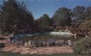
| Description: | Color postcard view of a rock garden with a rustic bridge and koi pond. Two monks are reading on the bridge. |

| Date: | 1942 |
|---|---|
| Description: | This map of Burlington shows plat of the town, city limits, section lines, 1/4 section lines of the plat sections, roads, railroads, rivers, and lakes. The... |
| Date: | 1897 |
|---|---|
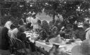
| Description: | The Meinhardt family assembled for a picnic in their garden. A river or lake is in the far background. The table is set with china and flatware. Among the ... |

| Date: | 06 12 1929 |
|---|---|
| Description: | This manuscript blueprint shows buildings with the names of their owners, tabernacle, location "where Strang found plates" and "house where Strang died," a... |

| Date: | 1960 |
|---|---|
| Description: | This standard U.S.G.S. topographic map was annotated by civil engineer and railroad historian James P. Kaysen to show the location of existing and defunct ... |
If you didn't find the material you searched for, our Library Reference Staff can help.
Call our reference desk at 608-264-6535 or email us at: