 Filter: Categories of Wisconsin Historical Images
Filter: Community of Burlington
Filter: Subject of transportation
Filter: Categories of Wisconsin Historical Images
Filter: Community of Burlington
Filter: Subject of transportation
| Date: | |
|---|---|
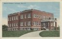
| Description: | Colorized postcard of the Memorial Hospital. Text at top left reads: "Memorial Hospital, Burlington, Wis." |

| Date: | |
|---|---|
| Description: | Black and white postcard of a river view of the Fox River as it runs through the city of Burlington. In the foreground is a railroad bridge. Just behind th... |

| Date: | |
|---|---|
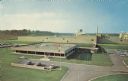
| Description: | Color postcard of an aerial view of Cerami's Island View Hotel Motel Resort on the shore of Brown's Lake. |
| Date: | |
|---|---|
| Description: | Color postcard of an elevated view of the Nestle Chocolate Factory. Text on back reads: "This ultramodern plant was opened in 1966 to supply Nestle Chocola... |

| Date: | 1930 |
|---|---|
| Description: | A group of men stand outside the Burlington Farm Machinery Company storefront where an International H-5 truck owned by the Mercer Transfer Company is park... |

| Date: | 1930 |
|---|---|
| Description: | An International H-5 truck with a 190" wheelbase and a refrigerated body parked in front of the Burlington Farm Machinery Company, an International Harvest... |
| Date: | |
|---|---|
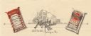
| Description: | Letterhead of the Murphy Products Company, with a three-quarter view of the company building and trucks, automobiles, and a train nearby, flanked on either... |

| Date: | |
|---|---|
| Description: | Color postcard view of a rock garden with a rustic bridge and koi pond. Two monks are reading on the bridge. |
| Date: | 1918 |
|---|---|
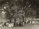
| Description: | Scene in a small city park showing a group of local women serving luncheon to soldiers recently returned from service in the first World War. Very possibly... |

| Date: | 1942 |
|---|---|
| Description: | This map of Burlington shows plat of the town, city limits, section lines, 1/4 section lines of the plat sections, roads, railroads, rivers, and lakes. The... |

| Date: | 06 12 1929 |
|---|---|
| Description: | This manuscript blueprint shows buildings with the names of their owners, tabernacle, location "where Strang found plates" and "house where Strang died," a... |
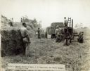
| Date: | 08 21 1924 |
|---|---|
| Description: | View of men working in a field with a Farmall tractor and wagon. A man stands by a stack of hay bales in the left foreground. Caption: "J.F. Deems Farm, Ro... |

| Date: | 07 14 1924 |
|---|---|
| Description: | Man driving a Farmall tractor pulling a wagon piled high with hay near the open door of a large barn on Deems Farm. The barn has a cupola with a lightning ... |

| Date: | 1960 |
|---|---|
| Description: | This standard U.S.G.S. topographic map was annotated by civil engineer and railroad historian James P. Kaysen to show the location of existing and defunct ... |
If you didn't find the material you searched for, our Library Reference Staff can help.
Call our reference desk at 608-264-6535 or email us at:
