 Filter: Categories of Wisconsin Historical Images
Filter: Community of Boscobel
Filter: Subject of botany
Filter: Subject of intellectual life
Filter: Categories of Wisconsin Historical Images
Filter: Community of Boscobel
Filter: Subject of botany
Filter: Subject of intellectual life

| Date: | 1869 |
|---|---|
| Description: | Birds-eye drawing of Boscobel, Grant County, depicts street names and street layouts, houses, rivers and trees. A reference key at the bottom of the map sh... |

| Date: | 1920 |
|---|---|
| Description: | Aerial view of the last covered bridge, which is no longer standing. |
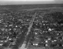
| Date: | 03 28 1949 |
|---|---|
| Description: | Aerial photographs of Boscobel, Wisconsin. |

| Date: | 10 24 1946 |
|---|---|
| Description: | Photographic postcard of an aerial view of town. Text below reads: "Aerial View — Boscobel, Wis." |
If you didn't find the material you searched for, our Library Reference Staff can help.
Call our reference desk at 608-264-6535 or email us at: