 Filter: Categories of Wisconsin Historical Images
Filter: Community of Baraboo
Filter: Subject of wisconsin river (wis.)
Filter: Categories of Wisconsin Historical Images
Filter: Community of Baraboo
Filter: Subject of wisconsin river (wis.)
| Date: | |
|---|---|
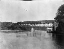
| Description: | View along right side of shoreline toward a Chicago, Minneapolis, and St. Paul train crossing a bridge over the Wisconsin River. |
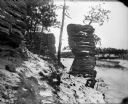
| Date: | 1910 |
|---|---|
| Description: | A winter view of Chimney Rock at the Dells. There is snow on the ground and ice on the river. |
| Date: | 1869 |
|---|---|
| Description: | Two girls in long dresses on a rock formation. The river and far shoreline is in the background. Text on left reads: "A Visit to Devil's Lake, Sauk County,... |

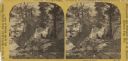
| Date: | 1866 |
|---|---|
| Description: | This manuscript map by Increase Lapham shows the Dells of the Wisconsin River, from Stand Rock and Witches Gulch at the north to a point approximately one ... |

| Date: | 1915 |
|---|---|
| Description: | This 1915 map covers the section of the Wisconsin River in southern Adams, southeastern Juneau, northeastern Sauk, and northwestern Columbia counties. A po... |
If you didn't find the material you searched for, our Library Reference Staff can help.
Call our reference desk at 608-264-6535 or email us at: