 Filter: Categories of Wisconsin Historical Images
Filter: Community of Ashland
Filter: Subject of transportation
Filter: Subject of recreation areas
Filter: Categories of Wisconsin Historical Images
Filter: Community of Ashland
Filter: Subject of transportation
Filter: Subject of recreation areas

| Date: | 1890 |
|---|---|
| Description: | Bird's-eye map of Ashland, viewed from Lake Superior, with insets of Prentice Park and Fishery. Population 16,000. Increase in Ten Years, 11,000. |
| Date: | 1935 |
|---|---|
| Description: | View of the Ashland Band Shell with benches, trees, and what is today Highway 2 in the foreground. On the left is a large metal tower, and in the backgroun... |

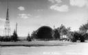
| Date: | 1947 |
|---|---|
| Description: | This map of Ashland is a cadastral map showing some rural landowners and includes index to points of interest. The map shows roads, railroads, parks, cemet... |

| Date: | 1900 |
|---|---|
| Description: | This map is shows land in white and water in blue and is indexed for parks, points of interest, schools, churches, and recreational areas. The map shows lo... |

| Date: | 1930 |
|---|---|
| Description: | A child is holding out a bowl to a pillar from which water is cascading down into a spring. In the background, two other children are walking up a dirt pat... |
If you didn't find the material you searched for, our Library Reference Staff can help.
Call our reference desk at 608-264-6535 or email us at: