 Filter: Categories of Wisconsin Historical Images
Filter: Community of Ashland
Filter: Creator Name of Unknown
Filter: Subject of land
Filter: Categories of Wisconsin Historical Images
Filter: Community of Ashland
Filter: Creator Name of Unknown
Filter: Subject of land

| Date: | 02 26 1887 |
|---|---|
| Description: | Bird's-eye map of Ashland, and the Apostle Islands in Lake Superior. Caption reads: "Ashland and the Apostle Islands." |
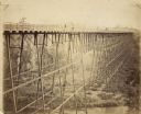
| Date: | 1885 |
|---|---|
| Description: | Elevated view of the Wiscsonsin Central's bridge over the White River, about six miles south of Ashland. The bridge was 1600 ft. long and 110 ft. above the... |
| Date: | |
|---|---|
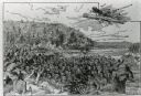
| Description: | An illustration titled "The Battle of the Brule" based on an 1840's battle between the Ojibwe and Dakota Sioux over territory in the Ashland, Wisconsin are... |

| Date: | |
|---|---|
| Description: | Elevated view across water toward mill ruins on the shoreline. A pile of logs are next to the dilapidated structure. In the far background is a bridge and ... |
| Date: | |
|---|---|
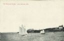
| Description: | View across water towards two schooners off the shore of Madeline Island, one of the islands that comprise the Apostle Islands in Lake Superior. Two large ... |

| Date: | 1800 |
|---|---|
| Description: | The map is ink and pencil on paper. Map shows the location of the Ashland Lumber Company as well as a portion of Ashland County. Portions of the map are in... |

| Date: | 1924 |
|---|---|
| Description: | This map is pen, pencil, and watercolor on paper and shows land ownership by name, local streets, railroads, and part of Chequamegon Bay. The map includes ... |
If you didn't find the material you searched for, our Library Reference Staff can help.
Call our reference desk at 608-264-6535 or email us at:
