 Filter: Categories of Wisconsin Historical Images
Filter: Community of Appleton
Filter: Year of 1900-1999
Filter: Categories of Wisconsin Historical Images
Filter: Community of Appleton
Filter: Year of 1900-1999
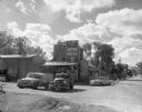
| Date: | 1960 |
|---|---|
| Description: | Exterior of Olsen's Mill (Wayne Feeds) on Hwy 49, just north of Hwy 21. |
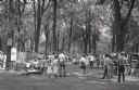
| Date: | 1955 |
|---|---|
| Description: | Prospective buyers examine artwork at an art fair at City Park. |
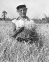
| Date: | 1955 |
|---|---|
| Description: | Louie Suttner inspecting the wheat crop at his farm, the current site of the Fox River Mall. |
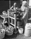
| Date: | 1960 |
|---|---|
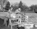
| Description: | Louis Suttner and another man making apple cider. |
| Date: | 1960 |
|---|---|
| Description: | Louis Suttner and another man make apple cider outdoors. |
| Date: | 1919 |
|---|---|
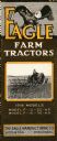
| Description: | Front cover of a pamphlet advertising Eagle farm tractors. Features an illustration of an eagle and a photograph of a man using a tractor in a field. |
| Date: | 1920 |
|---|---|
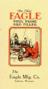
| Description: | Front cover of a pamphlet advertising the Eagle steel frame silo filler featuring a color illustration of two farmers using the filler. |
| Date: | 1920 |
|---|---|
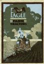
| Description: | Front cover of a booklet advertising Eagle farm tractors featuring a color illustration of a man using a tractor to plow a field in front of a farmhouse. |
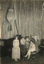
| Date: | 1924 |
|---|---|
| Description: | Jerry's Piano Girls, a Keith vaudeville circuit headliner act. |

| Date: | 1952 |
|---|---|
| Description: | Map shows roads, highways, railroads, parks, city buildings, schools, cemeteries, city limits, and the Fox River. The map is indexed by street name, street... |

| Date: | 1916 |
|---|---|
| Description: | Map shows roads, railroads, the Fox River, parks, and cemeteries. Wards are numbered and the edges of the map feature coordinates. The top left of the map ... |

| Date: | 1921 |
|---|---|
| Description: | Map reads: "1918. Revised 1921." Key to the map in upper right hand corner reads: "Residential Districts," "Local Businesses," "Commercial and Light Manufa... |

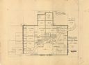
| Date: | 1931 |
|---|---|
| Description: | Map shows street map with wards numbered, the Fox River, railroads, playgrounds, cemeteries, and schools. The map also includes a manuscript annotation ind... |

| Date: | 01 1940 |
|---|---|
| Description: | Map shows roads, railroads, the Fox River, parks, schools, and cemeteries and is indexed by street name in the margins. The bottom of the map show the Winn... |

| Date: | 04 1956 |
|---|---|
| Description: | Map includes an index for building locations on the Lawrence University campus in the upper right hand corner. Map shows roads, rivers, campus buildings by... |

| Date: | 1957 |
|---|---|
| Description: | Map is indexed by street name in the margins. The map shows roads, highways, railroads, parks, city buildings, schools, cemeteries, city limits, and the Fo... |

| Date: | 1900 |
|---|---|
| Description: | Cabinet posed studio portrait of a young child with a toy in hand and formal dress. |

| Date: | 1968 |
|---|---|
| Description: | This map shows local streets, wards, buildings, parks, and part of the Fox River. The map is also indexed by street name. Ward borders and numbering and th... |

| Date: | 1960 |
|---|---|
| Description: | This map shows local streets, wards, public buildings, parks, and part of the Fox River. The land is shown in white and the water is shown in blue. The map... |
| Date: | 1949 |
|---|---|
| Description: | This map is ink and pencil on paper and shows land ownership by name, years of purchase, and city limits. Also included on the right and bottom margins are... |
If you didn't find the material you searched for, our Library Reference Staff can help.
Call our reference desk at 608-264-6535 or email us at: