 Filter: Categories of Wisconsin Historical Images
Filter: Creator Name of Wisconsin. Conservation Department.
Filter: Subject of water
Filter: Categories of Wisconsin Historical Images
Filter: Creator Name of Wisconsin. Conservation Department.
Filter: Subject of water

| Date: | 1936 |
|---|---|
| Description: | This 1936 Wisconsin Conservation Dept. map shows the locations of state forestry Civilian Conservation Corps (CCC) camps, closed state forestry CCC camps, ... |

| Date: | 1937 |
|---|---|
| Description: | This map shows the Wisconsin Conservation Department forest protection divisions and the locations of state forests, national forests, Indian reservations,... |

| Date: | 1937 |
|---|---|
| Description: | This Wisconsin Conservation Department map shows the locations of game refuges, fish hatcheries, canning factories, fish camps, and fish refuges in the sta... |

| Date: | 1937 |
|---|---|
| Description: | This Wisconsin Conservation Department map shows the locations of state forests, national forests, county forests, state nurseries, Indian reservations, st... |

| Date: | 05 01 1938 |
|---|---|
| Description: | This map shows the locations of Wisconsin Conservation Department forest protection districts and cooperative areas, state forests, national forests, India... |

| Date: | 1933 |
|---|---|
| Description: | This 1933 Wisconsin Conservation Dept. map shows roads, railroads, trails, lakes and streams, and the Trout Lake Game Refuge in Northern State Forest (whic... |

| Date: | 1956 |
|---|---|
| Description: | This map shows the types of upland and lowland forest vegetation on Stockton Island, one of the Apostle Islands in Lake Superior. |

| Date: | 1952 |
|---|---|
| Description: | This Wisconsin Conservation Dept. map shows sections, roads, rivers, and lakes in the Town of Cloverland, Vilas County, Wisconsin as of February, 1952. It ... |

| Date: | 1952 |
|---|---|
| Description: | This Wisconsin Conservation Dept. map shows sections, roads, rivers, and lakes in the Town of Presque Isle, Vilas County, Wisconsin as of March 1953. It do... |
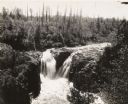
| Date: | |
|---|---|
| Description: | Elevated view of Copper Falls on the Bad River. Four people, one man and three women, are posing on rocks at the top of the falls. Surrounding burned-over ... |

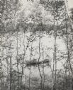
| Date: | |
|---|---|
| Description: | View through trees of Copper Falls, on the Bad River. |

| Date: | |
|---|---|
| Description: | Small lake showing 19 fishing parties in small boats, all in one area. |

| Date: | 1935 |
|---|---|
| Description: | Two men in a canoe on the Namekagon River in northwestern Wisconsin. |

| Date: | 1930 |
|---|---|
| Description: | View from shoreline of two men in a canoe running the Cedar Rapids on the Flambeau River. |
| Date: | 1930 |
|---|---|
| Description: | View through birch trees looking down at two men fishing from a rowboat near the shoreline. Another boat is tethered to the shore nearby. |

| Date: | 1939 |
|---|---|
| Description: | Reservoir used to store water for raising cranberries. A large group of people are walking around the perimeter towards automobiles parked in the distance.... |
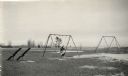
| Date: | |
|---|---|
| Description: | Recreational grounds near the beach at Terry Andrae State Park. A woman and a child are on a swing set. There are teeter totters on the left. |
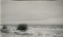
| Date: | |
|---|---|
| Description: | White sand and breaking waves along the beach at Terry Andrae State Park. |
| Date: | |
|---|---|
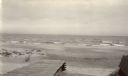
| Description: | Beach at Terry Andrae State Park. There is a wooden boardwalk in the foreground. |
| Date: | |
|---|---|
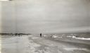
| Description: | View along shoreline showing the wide sandy swimming beach along Lake Michigan at Terry Andrae State Park. Two people are on the shoreline. |
If you didn't find the material you searched for, our Library Reference Staff can help.
Call our reference desk at 608-264-6535 or email us at: