Filter: Categories of Wisconsin Historical Images
Filter: Creator Name of Wisconsin. Conservation Department.
Filter: Subject of persons
Filter: Reproduction Rights of For Sale
Filter: Categories of Wisconsin Historical Images
Filter: Creator Name of Wisconsin. Conservation Department.
Filter: Subject of persons
Filter: Reproduction Rights of For Sale
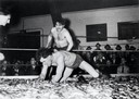
| Date: | 04 1939 |
|---|---|
| Description: | Two men smelt wrestling at the Smelt Carnival in Marinette. |
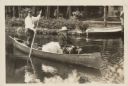
| Date: | 1928 |
|---|---|
| Description: | President Calvin Coolidge fishing at Cedar Island Lodge, rustic lodge of Henry C. Pierce, 35 miles from Superior, Wisconsin, on the Brule River. This lodge... |
| Date: | |
|---|---|
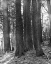
| Description: | White pines on the Menominee Reservation. A man is standing next to the trees on the left-hand side of the image. |
| Date: | 1935 |
|---|---|
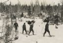
| Description: | Winter scene with four men walking on snowshoes through a forest. |
| Date: | 1935 |
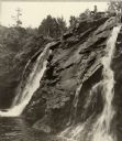
|---|---|
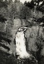
| Description: | Elevated view of the Brownstone Falls on the Bad River. |
| Date: | 1900 |
|---|---|
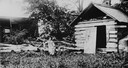
| Description: | A girl sits on a log next to Eleazer William's log cabin site. |
| Date: | 1935 |
|---|---|
| Description: | Fort Howard hospital sheltered by large trees. |

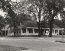
| Date: | 1949 |
|---|---|
| Description: | Fort Howard Hospital, Surgeon's Quarters. |
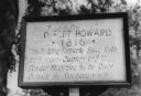
| Date: | 1940 |
|---|---|
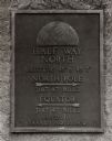
| Description: | Fort Howard hospital marker that reads: "Old Fort Howard • 1816 • This building formerly stood with the surgeons quarters and the powder magazine by the ri... |

| Date: | 1940 |
|---|---|
| Description: | View of the Jeremiah Curtin house located at 8685 West Grange Avenue. This stone and stucco residence was erected in the mid-1830s by Irish immigrants Davi... |
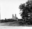
| Date: | 1950 |
|---|---|
| Description: | View looking up hill towards the Holy Hill monastery and church. |

| Date: | 1940 |
|---|---|
| Description: | Building used as a lodging house for the First Territorial Legislature held in Belmont in 1836. |
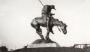
| Date: | |
|---|---|
| Description: | View of the bronze sculpture entitled: "The End of the Trail." |
| Date: | 1938 |
|---|---|
| Description: | The 45th parallel of north latitude marker, marking halfway between the equator and the north pole. The marker is located on Highway 141, three miles north... |

| Date: | 1930 |
|---|---|
| Description: | A view looking west at Rib Mountain across the Wisconsin River from the outskirts of Wausau. |
| Date: | |
|---|---|
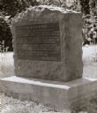
| Description: | Old Lead Road Marker. Marker reads: "The Old Lead Road. In 1828, ox-teams, guided along an ancient Winnebago Indian Trail, began hauling over this road. Ju... |
| Date: | 1940 |
|---|---|
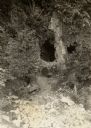
| Description: | A view of some caves at Peninsula State Park. |
| Date: | 1938 |
|---|---|
| Description: | Little Manitou Falls on the Black River. Referred to as the "upper falls" in the park. A person is sitting on the rocks on top of the falls. This waterfall... |
If you didn't find the material you searched for, our Library Reference Staff can help.
Call our reference desk at 608-264-6535 or email us at: