 Filter: Categories of Wisconsin Historical Images
Filter: Creator Name of Wisconsin. Conservation Department.
Filter: Subject of land use
Filter: Categories of Wisconsin Historical Images
Filter: Creator Name of Wisconsin. Conservation Department.
Filter: Subject of land use
| Date: | |
|---|---|
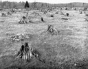
| Description: | Grass meadow with rotting tree stumps, possibly after a fire. |
| Date: | 1940 |
|---|---|
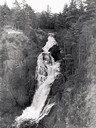
| Description: | Big Manitou Falls with trees and observation area. |
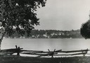
| Date: | 1940 |
|---|---|
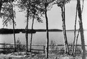
| Description: | View of trees along a fence in front of Boulder Lake. |
| Date: | 1935 |
|---|---|
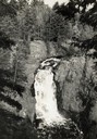
| Description: | Elevated view of the Brownstone Falls on the Bad River. |
| Date: | 1940 |
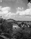
|---|---|
| Description: | Church, several houses and field from a hill. |
| Date: | 1950 |
|---|---|
| Description: | Downtown Ephraim from Peninsula State Park, directly across the bay. |
| Date: | 1940 |
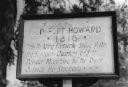
|---|---|
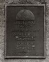
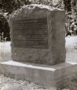
| Description: | Fort Howard hospital marker that reads: "Old Fort Howard • 1816 • This building formerly stood with the surgeons quarters and the powder magazine by the ri... |
| Date: | 1950 |
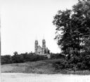
|---|---|
| Description: | View looking up hill towards the Holy Hill monastery and church. |
| Date: | 1940 |
|---|---|
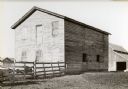
| Description: | Building used as a lodging house for the First Territorial Legislature held in Belmont in 1836. |

| Date: | 1940 |
|---|---|
| Description: | Building used as a lodging house for the First Territorial Legislature held in Belmont in 1836. |
| Date: | |
|---|---|
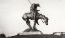
| Description: | View of the bronze sculpture entitled: "The End of the Trail." |
| Date: | 1945 |
|---|---|
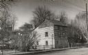
| Description: | A restored Cornish miner's house, called Polperro, on Shake Rag Street. The house was temporarily covered with siding, but after restoration the siding was... |
| Date: | 1938 |
|---|---|
| Description: | The 45th parallel of north latitude marker, marking halfway between the equator and the north pole. The marker is located on Highway 141, three miles north... |
| Date: | |
|---|---|
| Description: | Old Lead Road Marker. Marker reads: "The Old Lead Road. In 1828, ox-teams, guided along an ancient Winnebago Indian Trail, began hauling over this road. Ju... |
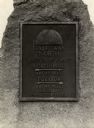
| Date: | 1940 |
|---|---|
| Description: | A view of a marker on highway 41 designating the half way point between the Equator and the North Pole. |

| Date: | 1942 |
|---|---|
| Description: | Warden Kramer and an assistant hold up confiscated sturgeon caught with illegal snag lines. |

| Date: | |
|---|---|
| Description: | View of a forest fire taken from an adjoining field. A fence separates the field from the burning trees. |

| Date: | |
|---|---|
| Description: | View across a field towards thick smoke billowing from a forest fire. People are in an open field in the distance. A road with trucks parked along it runs ... |

| Date: | |
|---|---|
| Description: | View down dirt road through cut-over and burned-over terrain. |

| Date: | |
|---|---|
| Description: | Small lake showing 19 fishing parties in small boats, all in one area. |
If you didn't find the material you searched for, our Library Reference Staff can help.
Call our reference desk at 608-264-6535 or email us at: