Filter: Categories of Wisconsin Historical Images
Filter: Creator Name of Wisconsin. Conservation Department.
Filter: Subject of formations (geology)
Filter: Categories of Wisconsin Historical Images
Filter: Creator Name of Wisconsin. Conservation Department.
Filter: Subject of formations (geology)
| Date: | 1940 |
|---|---|
| Description: | Big Manitou Falls with trees and observation area. |
| Date: | 1935 |
|---|---|
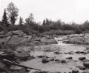
| Description: | View from rocky shoreline towards the Brownstone Falls in Copper Falls State Park. |
| Date: | 1935 |
|---|---|
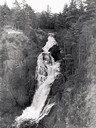
| Description: | Elevated view of the Brownstone Falls on the Bad River. |
| Date: | 1937 |
|---|---|
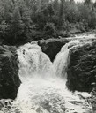
| Description: | Elevated view of the waterfall where the Bad River tumbles over the Keweenawan Trap Ledge. |
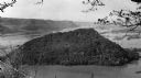
| Date: | 1948 |
|---|---|
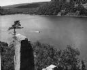
| Description: | View from the east bluff of lake with a motorboat. A geologic pinnacle juts out from the lower left of the image. |
| Date: | 1945 |
|---|---|
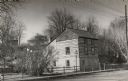
| Description: | A restored Cornish miner's house, called Polperro, on Shake Rag Street. The house was temporarily covered with siding, but after restoration the siding was... |
| Date: | 1950 |
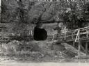
|---|---|
| Description: | View across river towards the tunnel leading to the bottom of the shot tower shaft at Tower Hill State Park. There is a rustic bridge on the right leading ... |
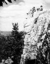
| Date: | 1936 |
|---|---|
| Description: | A rock outcropping with children at Rib Mountain State Park. |
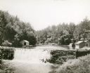
| Date: | 1930 |
|---|---|
| Description: | View of the mill dam on Dell Creek that creates Mirror Lake in Mirror Lake State Park (although the photograph was taken before the site was designated as ... |
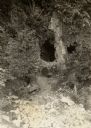
| Date: | 1940 |
|---|---|
| Description: | A view of some caves at Peninsula State Park. |
| Date: | 1938 |
|---|---|
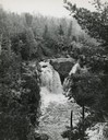
| Description: | Little Manitou Falls on the Black River. Referred to as the "upper falls" in the park. A person is sitting on the rocks on top of the falls. This waterfall... |
| Date: | |
|---|---|
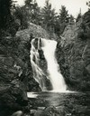
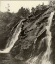
| Description: | Elevated view of Copper Falls on the Bad River. Four people, one man and three women, are posing on rocks at the top of the falls. Surrounding burned-over ... |

| Date: | |
|---|---|
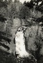
| Description: | View through trees of Copper Falls, on the Bad River. |

| Date: | 1930 |
|---|---|
| Description: | View from shoreline of two men in a canoe running the Cedar Rapids on the Flambeau River. |
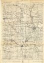
| Date: | 1940 |
|---|---|
| Description: | This quadrangle collection of maps, meaning geological surveys, shows sections of central and northern Wisconsin. The maps include a quadrangle index map. ... |
| Date: | 06 1936 |
|---|---|
| Description: | Caption reads: "Perrot State Park (Trempealeau vicinity), Wis. Mount Trempealeau, as seen from Brady's Bluff. View looking west. Photo by the Wisconsin Con... |
| Date: | |
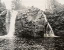
|---|---|
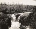
| Description: | View from below towards two waterfalls along a rock formation. A person is sitting on the rock outcropping between the falls. |

| Date: | 1935 |
|---|---|
| Description: | View towards an unidentified woman sitting and facing away from the camera to take in the view of the St. Croix River from a high rock formation. The bridg... |
If you didn't find the material you searched for, our Library Reference Staff can help.
Call our reference desk at 608-264-6535 or email us at: